If ever there was a “catch all” navigation tip, this is it. While determining a course to steer, the navigator needs to know and/or take into consideration:
- The relationship of Distance, Speed, and Time
- Conversion from True to Magnetic to Course to Steer
- Set and Drift, and their impact on the course steered
- How to correct a course to arrive at a specific destination
- Estimated position
All of which adds up to a feeling that if it isn’t talked about elsewhere, lets talk about it here.
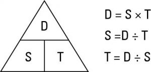 The Relationship of Distance, Speed, and Time – If any two are known, the third can be easily calculated using simple multiplication and division. The “D ST Triangle” to the right provides a great representation of the relationship of calculating distance, speed, and time.
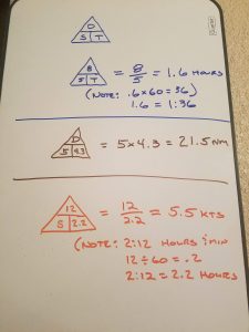 When using the triangle as an aid, D is always in nautical miles (e.g. 5.5 nm), S is always in knots (e.g. 6 kts), and time is always in hours (never minutes or hours and minutes). 90 minutes is not 1:30. 90 minutes would be represented as 1.5 hours. When doing D ST calculations, values to the nearest 1/10 generally provide sufficient accuracy for the coastal pilot. In use, visualize the horizontal line under D as a division sign, and the vertical line between S and T as a multiplication sign.
As can be seen in the examples, if give tenths of a hour, multiply the tenths by 60 to come up with minutes. If given minutes, divide the minutes by 60 to find tenths. If you can’t remember whether to multiply or divide, just pick one. If the answer doesn’t look right, do the other.
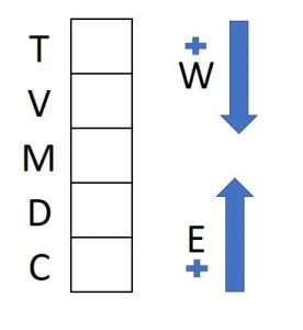 Conversion from True to Magnetic to Course to Steer – When converting directions, the TVMDC table shown here is invaluable. Conversions will become second nature, however, when first starting out, I recommend duplicating the table on a pad and using it to fill in and calculate direction.
- T = direction in degrees relative to true north.
- V = variation, taken from the center of the compass rose on the chart of the area you are sailing is the difference between true and magnetic north, and is stated as degrees west or east (e.g. 14E indicates magnetic north is points 14 degrees to the east of true north.
- M= direction in degrees relative to magnetic north. Degrees true, plus or minus variation, equals degrees Magnetic.
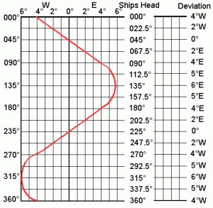 D = deviation is specific to the vessel and compass being used. Because of magnetic influences on the vessel, no compass can be adjusted to be perfectly accurate. Instead, adjustment gets it as close as possible, and a record, called a deviation card or a compass card, is kept of the differences. Deviation will vary at each heading, so the card records the difference at set intervals around the compass, generally 22.5 degrees apart. Deviation in between the provided headings can easily be estimated. 055º is approximately half way between 045º and 067.5º, therefor deviation would be 1ºE.
- C = ship’s compass (known as PSC or per ship’s compass)
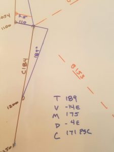
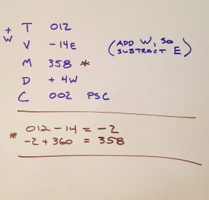 All of this seems quite complex, however, if the TVMDC table is drawn and used, it all becomes very simple. The course over ground from just north of Southeast Farallon Island to the entrance to Drakes Bay is “C 012”. Variation according to the compass rose is 14E, which is subtracted to get “C 358 M”. Deviation of 4W is added to get a course to steer of “C 002 PSC). All that’s left to arrive at Drakes Bay safely is to account for wind, current, helm error, typically grouped together as set and drift.
Set and Drift – technically, set and drift are limited to the impact on a vessel of the direction and speed of current in the area the vessel is passing through. Unfortunately, while underway current is nearly impossible to separate from the effects of leeway (wind) and helm error. Instead, all are typically lumped together as “set and drift” to show the net result. Set is direction and drift is speed.
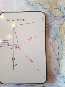 Back to our example of a Tradewinds Advanced Coastal Cruising class. On day one, the vessel is piloted out to G “8” of the Main Ship Channel through the San Francisco Bar. At 0954 a turn to the south is executed. The desired course over ground is “C 180”. Applying variation of 14E results in “C 166 M”. 5E of deviation at 157.5º per the chart above is used, resulting in a course to steer of “C 161 PSC”. DR positions are plotted for 1000, 1100, and 1200. At 1100, a fix was obtained (see Part 4 to follow) and it was determined the vessel is .6 miles away from the expected DR position, in a direction of 110º. Set therefore is 110º. Drift will require further work, because the .6 miles is over 1 hour and 6 minutes, not over 1 hour as required. Using the D ST triangle, distance is .6 divided by 1.1 hours equals 0.545, so set is approximately 0.5 knots. You can also find a DR 1 hour from the DR start time of 0954, draw and measure the set.
How to correct a course to arrive at a specific destination – A new course line can now be drawn from the fix location to the location of the next turn. The new course to the next turn point is C 184. However, if you steer that course, you will end up .5 miles of target due to set and drift. To correct for set and drift, continue the set line thru the fix location for a distance equal to the drift. In this case, 0.5 miles. Draw a line from that point, to the DR location 1 hour later. The course line to correct for set and drift is 189º, and should be relayed to the helm as “C 171 PSC”. Steering that course should result in a course made good of 184º, allowing you to reach the next turn at approximately 1250.
Estimated position – every skippers tip should have a bit of controversy in it, right? If so, here it is. The term “estimated position” is used differently by different authors and publications. One such usage involves estimating a position based on a DR position and a single line of position (LOP), like a bearing to a charted object. The process involves drawing a line that runs perpendicular to the LOP, running through the DR position. The estimated position is the point the perpendicular line crosses the LOP. Sadly, I have had times where the error in this estimate was unacceptable. On one occasion, I was able to get a fix by using a bearing and the depth. I was 1.3 miles of of the Farallons, but an EP calculated at the same time had me 2.1 miles out, simply because I was travelling .2 kts faster than my DR indicated. Others will argue, however, I don’t recommend the use of estimated position in that manner unless there is no other choice. Neither does The American Practical Navigator as it isn’t even in the book.
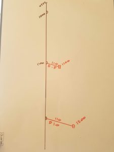 Instead, an estimated position is correcting a DR plot for known set and drift. In the above example, if I consistently have a set and drift of 110º/0.5 heading south from buoy G “8”, then it would make sense to note it as part of my DR during later voyages. You will note in the illustration I did not reset my DR to the EP. Instead, I just noted it, and would include the information in developing my DR expansion circles. The DR should only be reset with a fix or a running fix.
I hope you stuck with me this far. If so, you will be happy to know that I my opinion, you have survived the most challenging part of coastal piloting.
How great is this, so simple and excellent screenshots to help! Thank you!
Hello Don,
I got lost on the drift in this example above. everything made since till the noted 1100 DR /2 position fix confused me. you draw out that the drift in NM noted was 5.6 at 1100. My assumption was that you take this 5.6 (determined by measuring with dividers ) and then divide it by the time, to get (knots) in drift. 5.6/1.0 hr. or 1.1 hr. is still 5.6 knot or 5.1 knots drift. You say .6 miles were determined for Drift? I get the difference between 1054h and 1100h gets you the .6 mile difference. between those 2 DR’s, I’M just lost right there on total drift. sorry. Help! Set= 110
Drift = 5.6?
Thanks, Robert
Hi Robert. In this case the problem stems from my handwriting. It’s not 5.6, its S .6
In other words, Speed .6
Sorry for the confusion.
Lol. I get it now. Thanks a bunch