As I write this, I am preparing to instruct a July 27 Advanced Coastal Cruising class. Part of the class preparation required of each student involves determining the best time to transit the Golden Gate the morning of July 28. One primary factor to keep in mind is the currents. To the casual observer, the logical time to leave the bay would be during an EBB so that you can “ride the current out.” This is actually the worst time to go. The EBB will meet the ocean swell and the wind, both coming in, creating some rather interesting, and sometimes dangerous, conditions the 8 miles from the bridge to the outside edge of the San Francisco Bar. I generally time my exit for the slack before the flood in order to avoid the EBB, and have as little Flood as possible.
However, the best time to exit the Golden Gate isn’t the point of this tip, were to find information about tides and especially currents is. I use four different sources (one book and three internet sites) to get expected tide and current data. Knowing that, recognize that all four sources are “estimates of expected” tides and currents. Basically, that means all four are different, with times varying by nearly 2 hours on the first slack of the day, to a 1.7 knot difference in the 0820(ish) EBB.
With that much difference, who do you trust? Easy, whichever one you happen to have available. The important thing is to use something. Keep in mind, every source is an estimate. As long as you recognize that you will be OK with whichever source you pick. More critical than which source you use, is … are you actually remembering what you see? Did you look at it and just jot down the slacks and the extremes because that is what you were trained to do? Or, are you really making a mental picture of what will be happening during your sail?
As an example, current information for each of the four sources is shown below (along with links as appropriate … bookmark them and use them.)
Currents 0.2 miles SE of Point Diablo (The Golden Gate)
2017 San Francisco Bay & Delta Tide Book
0148 S 0218 2.6 F 0512 0818 1.9 E 1130 S 1442 3.2 F 1800 S 2100 1.5 E
University of Nevada, Reno Tides and Currents
http://wolfweb.unr.edu/homepage/edc/tides/2017/sfbe_fr17.html
0001 S 0222 2.0F 0448 S 0813 3.2E 1155 S 1444 2.7F 1739S 2103 2.8E
University of South Carolina
http://tbone.biol.sc.edu/tide/tideshow.cgi?site=San+Francisco+Bay+Entrance+(Golden+Gate),+California+Current
0237 2.65 F 0543 S 0825 3.62 E 1211 S 1510 3.19 F 1824 S 2102 3.14 E
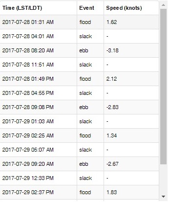
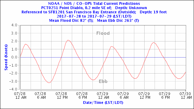
NOAA (see images below)
https://tidesandcurrents.noaa.gov/noaacurrents/Regions
0131 1.62 F 0401 S 0820 3.18 E 1151 S 1349 2.12 F 1655 S 2108 2.83 E
If I want to time my arrival at The Golden Gate for slack before flood, I should be at the bridge between 1130 and 1200. I can expect a flood of varying intensity up to 3 knots for the next 6 or so hours. Transiting the Golden Gate and crossing the San Francisco Bar covers approximately 8 miles. With a speed through the water of 5.5 knots, it will take about 1:30. However, because of the flood I can expect to add 15 to 30 minutes to my transit time. If I arrive at the bridge at 1130, I should be through the bar by 1330 and able to make a turn south for Half Moon Bay 20 miles away. At 5.5 knots of boat speed my arrival in Half Moon Bay should be approximately 1700. A quick check of the NOAA tide prediction site indicates a 5+ foot high tide an hour before my arrival. Net result, I should have plenty of daylight left and lots water under my keel when I pull into Pillar Point Harbor.
 As far as my personal preferences regarding which source to use. I ALWAYS carry a tide book in my PFD and use it if I don’t have internet access. If I have internet access, I use the NOAA site because of the options and variety of reporting locations (of the 332 reporting locations found within California waters, there are 39 reporting locations covering every aspect of the approaches to and through The Golden Gate.) Predictions are given in both text and line graph formats and can be downloaded in text, excel, or web formats for easy saving and/or printing. And, it’s first person data instead of being interpreted by someone else.
In closing, find and use a tide and current reporting source that you trust. Understand what the information means, and know what is happening at all times during any sail. I feel so strongly about it that if you are in one of my Bareboat or Advanced Coastal classes, at some point I am going to ask what is happening with the tides and currents. If your answer is “I wrote it down in the log book,” I will be sad.
Also, one needs to remember to take all that info with a grain of salt, especially the printed one, and pay attention to external factors. The tide book is calculated by formulas 1 year in advance and doesn’t take into account the actual weather. The NOAA website is a little better, but it still can be wrong.
I almost got stuck at the gate trying to come back in despite using the book systematically. The vast amount of rains this winter added 2 to 3 knots of current to what the book said.
Result the boat VMG went down almost to zero once we turned around under the bridge, and that was just about the”predicted” slack time.
The times in the book was wrong, the current was wrong. The buoys around the bay knew better and now I double check the current prediction with visual cues before crossing the bridge.
Don, Have you seen the tidal current animations based on high frequency radar?
https://tidesandcurrents.noaa.gov/ofs/ofs_animation.shtml?ofsregion=sfb&subdomain=la&model_type=currents_forecast
Good for planning a trip to Drakes Bay.
Don,
Excellent article on one of my favorite subjects. For those of you interested in the forces that influence our tides I highly recommend “Beyond The Moon” by James Mccully which has all the science you’d want and still manages to be very readable.
What are examples of discrepancies in tidal information? Don’t they all originate in NOAA’s National Ocean Service, and if that is the case, wouldn’t they be the result of transcription errors or software glitches?
Don: I appreciate these blogs a great deal. As a former member of Tradewinds, I have always felt I received great instruction in all the classes. But you can never learn all there is to know about sailing. So, I’m a dedicated life long learner.
Art Ewart
Dream Catcher
SYH