Sailing into an unfamiliar harbor is fraught with peril for mariners, terrifying if you are seeking shelter from a storm. The entrance to San Francisco Bay is one of the most dangerous on the West Coast. The combination of strong wind, traffic, current, fog, and dangerous waves created when storm seas meet the Fourfathom Bank against an ebb is so treacherous that there are over 300 shipwrecks just seaward of the Golden Gate.
We had several very difficult approaches on our circumnavigation of 2001-2003, one of which resulted in a grounding, and several had our hearts in our throats. We never entered harbors after nightfall, standing off all night even in heavy weather, to avoid it. The one time we broke this rule was in Manzanillo in calm weather, and it almost did us in.
You don’t want to ground your ship on a shoal or rock. This problem has been recognized by mariners since time immemorial, and dealt with by numerous means. In the great days of exploration, Columbus, Magellan, and Cook would send small boats into an inlet to find a fairway, as the waters they sailed had never been charted. Lead lines, like the ones these boats would have employed, have been in use since at least 500 BC. It took a long time for mariners to survey the entire world of coves and rivers. Late friend Hank Strauss, a sailor who participated in the ’79 Fastnet Race, took soundings for the US Navy at the Solomon Islands in WWII because of a lack of reliable information, so this process was not completed until very recently.
Once a safe way in was found into a frequently visited river or harbor, a “pilot,” a person with local knowledge, was engaged to guide sailors in. The earliest mention we have of this practice is found in Homer in around 700 B.C. We hired a pilot in Borneo to help us navigate the Kumai River and its tributary, the Sekonyer. Fishermen there and in many other places in the third world have no navigation marks, no charts, no depth sounders, and no GPS. They just know the river. In San Francisco, where we welcome over 8,000 ships a year from all over the world, piloting is a stressful, highly-paid job done by mariners with very, very high levels of knowledge and experience. They have to be skilled in piloting both bars and rivers, as they take ships, some that are larger than the Sales Force Tower laid sideways, all the way to Sacramento. They have to be able to draw all the charts of the area from memory complete with marks, just as a London cabbie has to know every street.
When the shoals and hazards had been established, various methods were used for locals to mark the way for themselves, or for others following. Although early sailors traded tips on getting into this or that harbor, there wasn’t an organized procedure. This was how it was for thousands of years of shipping, and then in the 13th century, charts and buoys began to appear. That earlier navigators managed with minimal or non-existent aids is a measure of their resourcefulness. Or daring. Or insanity.
One ancient method of indicating the way was to designate range marks on land. Mariners lined these up and followed them to make a safe passage. Sometimes those were a church and a tree, or two rocks. We still use that concept today in modern marks, and they can be seen in the San Rafael Channel and at the end of Potrero Reach. Modern marks are two rectangles with a central vertical stripe, a higher one behind a lower one.
Range marks show the middle of the channel, and lateral marks, which make up the majority of Aids To Navigation (ATONs) in our Bay, show the edges. At first these were just sticks, as are still seen in the third world and even in the US in minor waterways. If you go to Lawson’s Landing in Tomales Bay, you might be able to see the sticks just offshore locating the edge of the channel between sand bars, which are not official ATONs and are not on the chart. At Lawson’s they indicate only one side of the channel, but which side? There’s your problem. The official marks leading into the San Rafael Channel are also on only one side, but as they are colored green, we know to leave them to port. Keep a sharp watch.
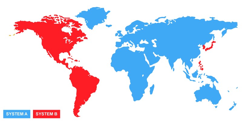
It is difficult to construct a detailed account of the history of these arrangements. The newborn US created The United States Lighthouse Establishment, later known as the U.S. Lighthouse Service, in 1789. By the mid-nineteenth century, a nascent lateral buoy system was developed by a few countries in northern Europe. Standardization included red marks on the right and black, later green, on the left when returning to a harbor. According to legend, this setup originated in the Port of Liverpool, often visited by American ships, and the US Congress adopted their Lateral System nationwide in 1848. By the early twentieth century there was still only sporadic agreement on markings between nations, but in 1957, 20 countries got together to form the International Association of Lighthouse Authorities, or IALA. In 1971 there was an accident with major casualties in the Dover Strait in the English Channel which lent urgency to organizing a more consistent arrangement, so in 1973 the IALA began to sort out all the disparate local systems with intent of unifying them. The result was adopted in 1980, but even then, because of the potential for confusion resulting from changing familiar marks, it was only possible to distill the various systems down to two separate groups: region A and region B. We’re in B. For lateral buoys in IALA-A, it is green, right, returning rather than the reverse that we use. In that system red ones are on the left but are still even numbered. However, they are shaped like cans, and the green ones on the right are pointy. Take note of this if you’re sailing in Europe or the South Pacific.
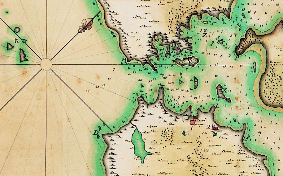
Back to San Francisco. The first chart of San Francisco Bay was created by José de Cañizares in 1776. He was an ensign on the first ship ever to enter the Bay, the San Carlos, commanded by Juan Manuel de Ayala after whom our favorite Cove is named. Believe it or not, Ayala had planned to do the survey but was incapacitated because he literally shot himself in the foot. You’ll see soundings, but no aids to navigation on this chart.
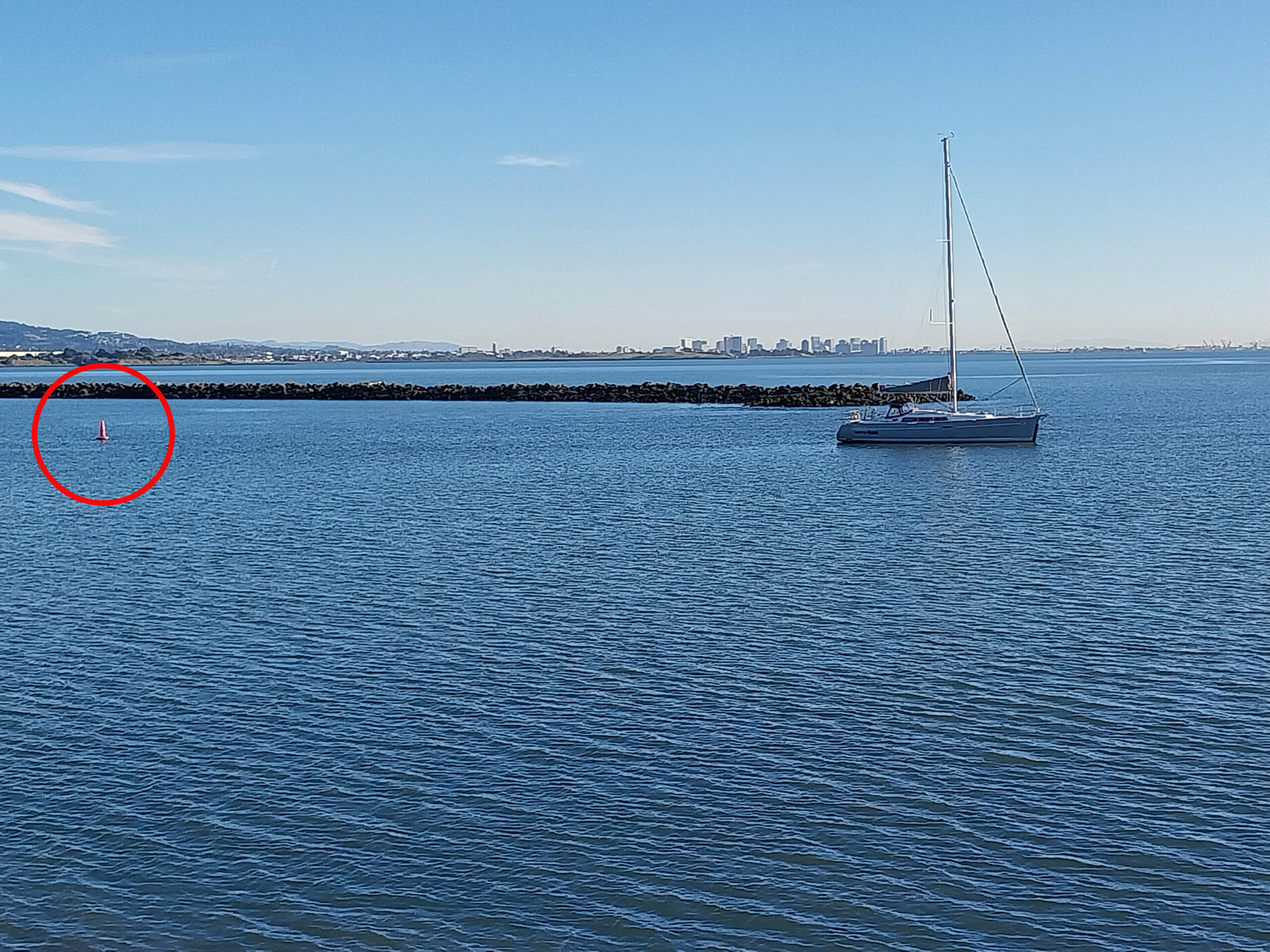
However, now we have them, and despite this, if you sail long enough on San Francisco Bay, you will touch somewhere. Don’t ask how I know. But those red marks in the Ford Channel will keep you safe if you observe them. This unfortunate skipper seems to have missed the memo, and is aground just outside the red mark. Be conservative near these marks, as just inside there isn’t a strait drop. Mud sloughs off at an angle to the bottom of the dredged channel.
You probably have learned that the green marks that look like cans are called “cans,” and the red ones which are cone-shaped, “nuns.” The common explanation for this is that nuns wear pointy hats. This always befuddled me. Have you ever seen a nun wearing a pointed red hat? A perusal of that source of all wisdom, the Internet, revealed scores of pictures of nuns in their habits, contemporary and historical, but only one had a point.

A much more likely explanation for the origin of the nickname for the red buoy is found in John Rogers’ Origins of Sea Terms. Rogers, a pretty reliable source, writes that “It appears to have gotten its name from the early English word nun, for a child’s top that was tapered on both ends. The word comes from the Old English nunna, with the same meaning.”
It’s taken thousands of years and a lot of dangerous, sometimes tragic surveys to get to the system we have today, when all major harbors and most minor ones are marked. Now all we have to do, as beneficiaries of this hard-won history, is pay attention to what the marks are telling us.