I’m not a fan of the term Coastal Navigation. It has become quite popular over the past several years, however, it’s a bit too vague to properly describe the process of safely operating a vessel in coastal waters. The proper term, used for at least two centuries, is Coast Piloting. Piloting is navigation which involves determining the position of a vessel relative to geographical/terrestrial reference points. With coast piloting, the reference points can be visually seen and then identified or matched to a reference on a chart of the area. To be able to identify that point on a chart requires you to have a pretty good idea of where you are to start with.
As an example, a chart of Drakes Bay in Northern California looks very much like San Quintin Bay in Mexico, over 600 miles to the southeast. Not having a general idea of where you are will result in some major errors in navigation. 15 miles south of Drakes Bay, 5 miles offshore, is safe water nearing the approach to The Golden Gate. 15 miles south of San Quintin, 5 miles offshore, is the Sacramento Reef, one of the most dangerous reefs on the pacific coast. Not a good mistake to make. The answer to having a good idea of where you are is Dead Reckoning (aka DR, Deduced Reckoning, or Ded Reckoning,) which is the primary topic of this tip.
Dead Reckoning is determining the position of a vessel by applying the ship’s course and speed to the last known accurate position (fix.) An ongoing plot of course, speed, time, and distance is marked on a chart, resulting in an approximate vessel position. A DR position is an approximate position, not allowing for the effects of tide, current, wind, helms person error or compass error. Whenever possible, the DR position must be updated to a more accurate fix, using bearings to visible objects and other lines of position that might be available.
A DR plot requires a known starting point, and is referred to as “taking departure.” This would be your last known accurate position fix, and is marked on the chart with a ⊗ as well as the time (noted horizontally on the chart). The size of the circle represents the degree of accuracy of the fix. This, and subsequent “expansion circles” around later DR positions indicate all possible positions of the vessel, and will be discussed further below.
Items to be included in the plot are:
- Time of each DR and/or fix position using 4 digit military time with no punctuation (e.g. 0800 or 1500)
- Time is written horizontally for fixes, and diagonally for DR positions
- Course line (carried out for two extimated future DR positions)
- Above the course line, the letter C followed by the 3 digit course in degrees true for the ordered course (e.g. C 165). The letter T is not needed. Although many professional navigators will disagree, it is not recommended that courses are designated in degrees magnetic.
- Vessel speed in knots (e.g. S 5)
Update the DR plot at least:
- Once an hour, on the hour
- At every course (or speed) change
- Any time a line of position is established
At every fix (including running fixes) the DR plot should be reset and a new DR plot begun.
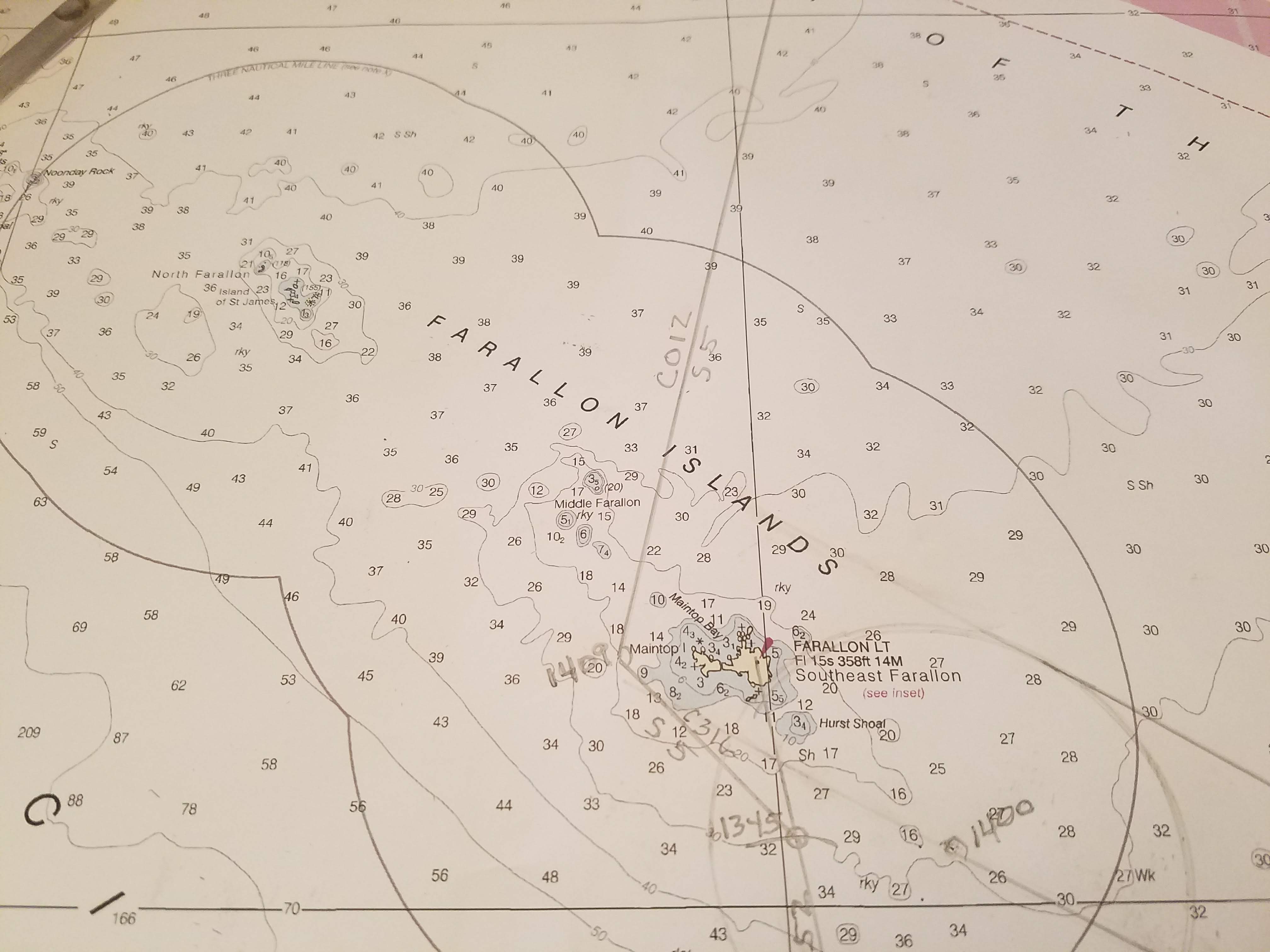
In this example taken from day two of the Tradewinds Advanced Coastal Cruising class, departure was taken at the Pillar Point safe water buoy [RW “PP” Mo (A)] at 0900, on a course of 300 degrees true to pass just to the SW of Southeast Farallon Island. Speed was set at 5 knots. Visibility due to haze/thin fog was estimated to be approximately 1 mile, therefore, no identifiable features would be available to take a bearing until arrival at Southeast Farallon.
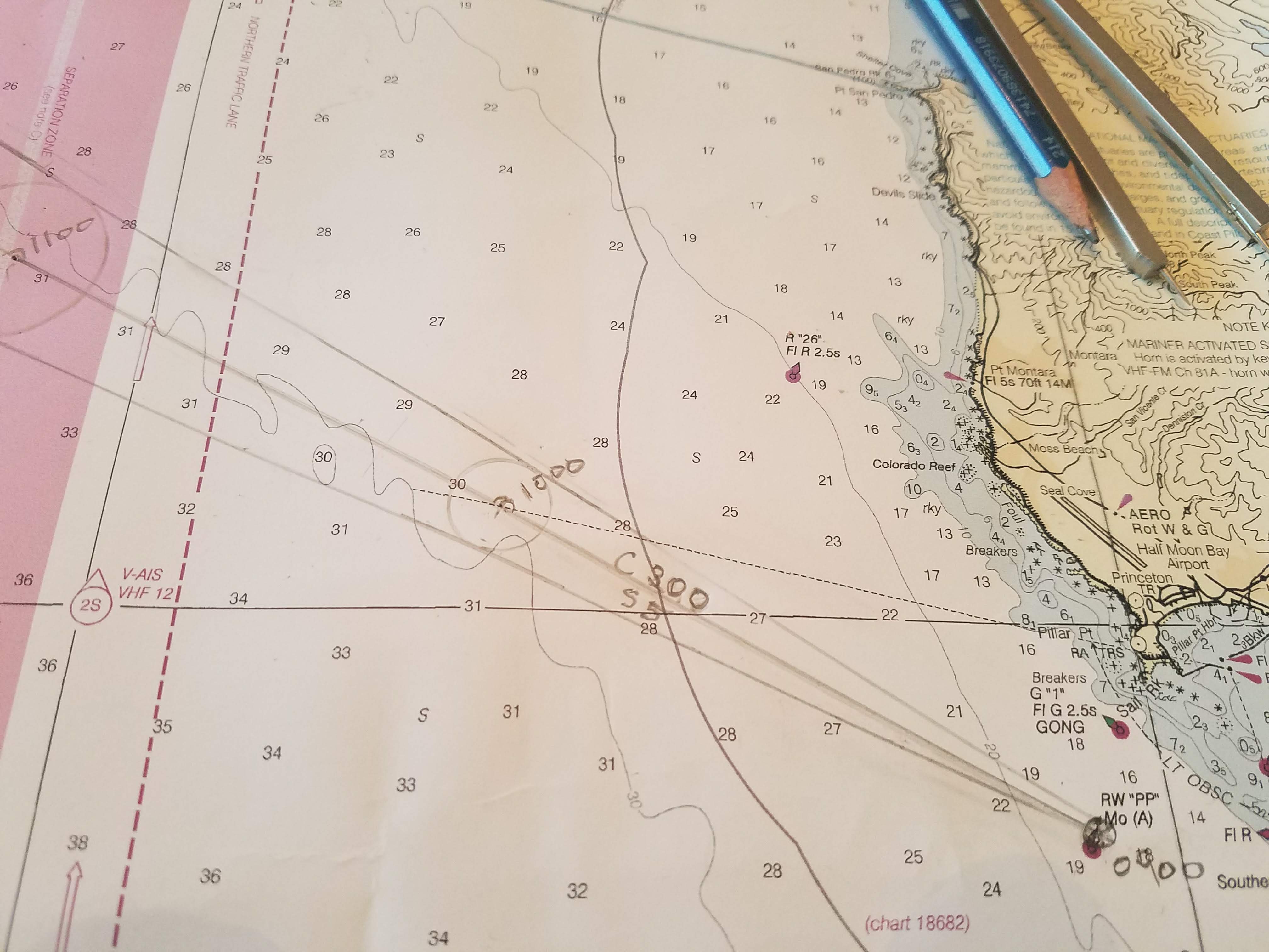
As a precautionary measure, the navigator assumed a possible steering error of 5 degrees, and created an expansion circle around each DR position. Knowing that a traffic separation zone would be reached approximately 7.5 miles into the planned course, and would require nearly an hour to cross, the watch was notified to pay special attention to possible commercial traffic from 1030 to 1130.
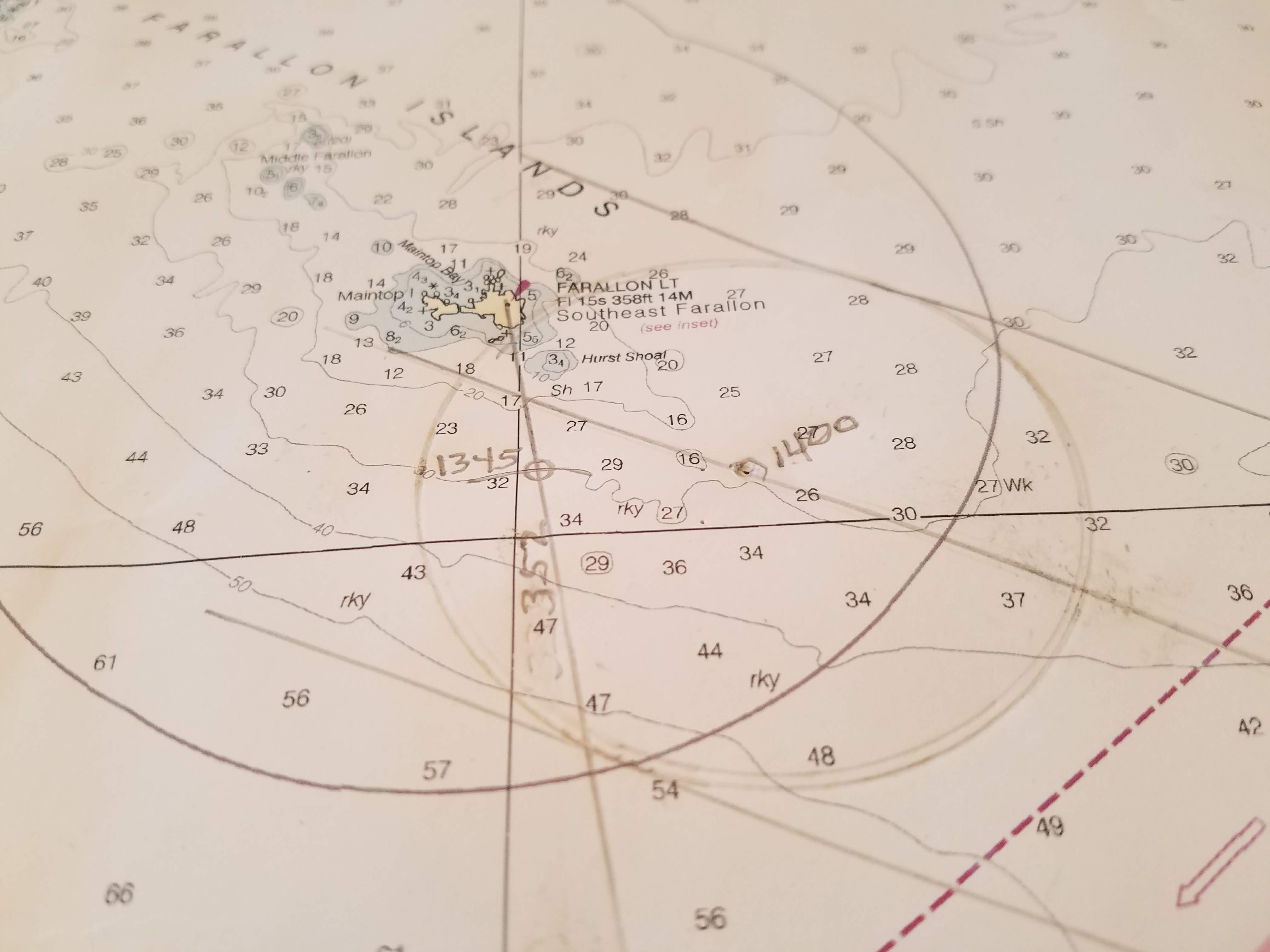
Estimated time of arrival off Southeast Farallon was 1400. At 1345, Southeast Farallon Light was sighted through the haze, and a bearing of 338 degrees magnetic was taken. Variation was applied, and a bearing of 352 was laid out on the chart, providing a single line of position. A depth of 180 feet was noted, providing a second line of position, and a fix obtained. Based on the fix, the average speed over ground was 5.2 knots, and the steering error was only 2 degrees. The DR was reset to the new fix, and the remainder of the trip to Drakes Bay plotted. C 316 for 24 minutes, followed by a turn to C 012. Estimated time of arrival at the entrance to Drakes Bay 1745.
Thank you Don, this is one to read again and supplement other texts (Chapman and Annapolis come to mind.) I appreciate the context you provide of our own sailing grounds.
I am interested to hear at sometime the arguments for including magnetic vs. not.
Thanks for the instruction!
JD
The Pictures of the plotting on the charts really clarifies the process. This inspires me to pull out the bay charts next time im out sailing. Thanks for this article!