
From: Gary G
Sent: Thursday, April 28, 2016 12:37 PM
To: Matt K
Subject: Weather forecasts
Hi Matt,
I’ve noticed a dramatic difference in weather forecasts recently for Richmond in particular between the Weather Underground and the Richmond NOAA site on our Tradewinds page.
For example as of noon Thursday (today) WU has Saturday’s forecast for Richmond as:
Sunny. Gusty winds diminishing in the afternoon. High 79F. Winds N at 20 to 30 mph. Winds could occasionally gust over 40 mph.
While the Richmond NOAA forecast is: Sunny, with a high near 75. Calm wind becoming north northwest around 6 mph in the afternoon.
I realize that art and science are both at work here, but these differences are significant. Aside from picking the worst and being relieved when it doesn’t happen, I don’t have an explanation for students to help them develop their sailing plans.
As always, your insights are appreciated! -Gary
From: Gary G
Sent: Thursday, April 28, 2016 3:02 PM
To: Matt K
Subject: FW: Weather forecasts
Hi again Matt,
I see now a few hours later Thursday afternoon that the forecasts are moving closer together for Saturday. Is the answer to why the forecasts were so different because they each update on different schedules and also use different analytics? Is there a site that you prefer when making weather related decisions for Richmond and the Bay? I used look at Weather Underground but now I’m not so sure. Again, thanks a lot for your time! -Gary
From: Matt K
Sent: Thursday, April 28, 2016 3:10 PM
To: Gary G
Subject: RE: Weather forecasts
Is the NOAA forecast you are looking at for a much larger area? That usually accounts for the difference, the NOAA forecast is averaging a large area like “SAN PABLO BAY SUISUN BAY THE WEST DELTA AND SAN FRANCISCO BAY NORTH OF THE BAY BRIDGE” and the WU forecast is for a much smaller area.
Matt Kepner
Tradewinds Sailing School & Club, Inc.
From: Gary G
Sent: Thursday, April 28, 2016 3:29 PM
To: Matt K
Subject: RE: Weather forecasts
Thanks Matt. I was looking at the NOAA site listed as Richmond Weather (it lists its focus as 2 miles S Richmond). I asked the question because the two sites were so very different earlier today, and I saw a similar thing at one point last week. Thanks for getting back to me. Cheers! Gary
From: Matt K
Sent: Thursday, April 28, 2016 3:35 PM
To: Gary G; Larry M
Subject: RE: Weather forecasts
Hmm you are right, there is still a large discrepancy.
Weather Underground:
Saturday 0 % Precip. / 0 in
Sunny skies. High 78F. Winds N at 15 to 25 mph. Winds could occasionally gust over 40 mph.
NWS:
Sunny, with a high near 76. North wind 6 to 11 mph increasing to 13 to 18 mph in the morning. Winds could gust as high as 23 mph.
Maybe our resident weather instructor has some input as to how to help explain this to the students?
Matt Kepner
Tradewinds Sailing School & Club, Inc.
Matt and Gary,
Great observations by Gary and great thinking by Matt. I think you’re both on the right track.
The Monterey office of the National Weather Service uses raw data from several numerical models, plus local knowledge, plus whatever happened yesterday, and then they write the forecasts from scratch. As Matt pointed out, the NWS writes Zone Forecasts that cover a large area…not quite mesoscale, but not neighborhood scale, either.
Weather Underground uses their own proprietary numerical modeling plus the same models as the NWS and it also uses a network of personal automated weather reporting stations to provide empirical data. The WU forecasts are probably rarely modified by humans…it’s mostly the output of their computers.
There are some other important differences between NWS and WU:
- WU uses a 4 km grid in their analysis; NWS uses a 5 km grid. The smaller grid requires more processing power and generates a more granular forecast.
- WU constantly adds weather station empirical data and updates every 15 minutes…NWS updates every 4 hours. More computing power.
- WU uses radar and satellite imagery to determine current state of sky conditions. NWS relies on reports from local airports. More computing power
- WU is in this for the money and they sell forecasts (for a lot of money) to private interests. NWS is public service of the US Government. WU needs to provide detailed and accurate forecasts.
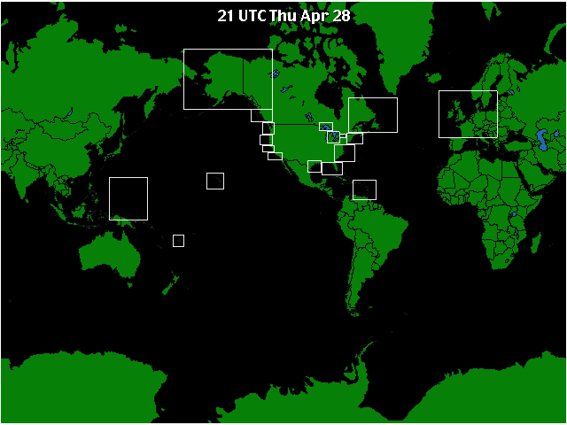
- The NWS and its sister agencies (Ocean Prediction Center, National Hurricane Center, etc.) produce weather products across several continents and oceans. WU only concentrates on those areas that have rich commercial potential, shown on the map below. The white boxes indicate their forecast maps. There’s a lot of area left over that NWS covers but WU doesn’t. It’s a little bit like using PC Metro for your cellphone carrier. God, they’re great in the city but then they suck real bad once you get east of Sacramento.
Does this help explain why there would be differences?
Let’s get Gary looking at the Area Forecast Discussion. It’s the best way to get plugged into the larger picture of what’s going on in our area. You’ll find the AFD for SF Bay Area here.
Jeez, this is a lot more interesting than what I’ve been working on today. Thanks for including me!
Larry M
Here is an interesting website that seem to be more accurate regarding wind on the Bay:
http://www.predictwind.com/