In your intro to navigation you’ll be shown charts
that display soundings in feet, fathoms, and meters. These units are entirely
arbitrary, generated not by science but by history, the details of which are
often murky. Ancient units were often, naturally enough, generated from human
body parts: a foot (now standardized to 12 inches), a step or pace (which
became the yard, 36 inches), a hand (4 inches), and a fathom (6 feet), which
was originally the outstretched arms of a man. The
meter is ever-so-slightly more scientifically based (don’t
trouble yourself with that link) and is part of the International System of
Units, abbreviated SI, the most commonly used system worldwide but not here.
In America, we consider it our patriotic duty to avoid being like everyone
else. This makes communicating with others a bother, which it should be. We
also have red, right, returning although much of the world uses green, right,
returning. We pity them.
Nautical history, being long and multicultural, is a
mish mash of all kinds of terms and units of measure like “chains” (66 feet)
and “shots” (roughly an ounce unless you’re friends with the bartender) or “shot
of chain” (90 feet or 15 fathoms) which is a different unit from chains or
shots. A shot is usually the same as a “shackle” but I wouldn’t count on it. The
“chain” is more of a lubberly term; one-quarter of a chain is a rod, and 80
chains is a furlong. But what you sailors want is a “cable”
(I wouldn’t read that either) which is 120 fathoms or 720 feet American
although the French, with their hoity-toity SI system, say it is 200 meters
which works out to about, although not exactly, 109 fathoms.
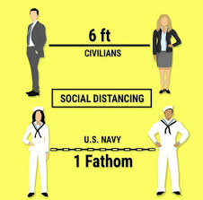
The fathom, as far as I know, is always used for
depth. (Don’t go into the Home Depot and try to order five square fathoms of
carpeting. Or actually, go ahead, give it a try.) Thus we have the phrase, to
“deep six” something, based on the tradition of burials at sea, which require
the body to be lowered to at least six fathoms. Still, in clear water, this
would not obscure the remains of the departed.
So, to summarize, as a practical example we can give
the following. Once I sailed through the Corinth Canal. The canal is 28 stadia
or 23 cables or 256 chains or 9/10 of a league or 2816 orguia, if it’s easier
for you to think in those, or 16,896 feet or 1,024 rods or 25.6 furlongs or
9,300 cubits (in biblical cubits; but of course in classical Greece, it would
have been 11,140 cubits, due to inflation), 3.202168898848118 statute miles, or
for us sailors, 2.7826086956521739 nautical miles long.
I hope this clarifies things.
Is there a salty term that you’d like to know the meaning or origin of? Many of of the terms and sayings that we use in every day life have nautical origins. Send us your questions and we’ll pass them on to Tony for thorough research and explanation!
Capes, points, and headlands are difficult challenges for mariners. If you have been certified at the BKB level, perhaps you have already encountered a problem returning to Potrero Reach from Keller Cove, the open area between Point Richmond (the old ferry dock) and the Chevron Pier. Sailing upwind against an adverse current, you may have found it frustrating to try to turn the corner past the pilings, each tack seemingly depositing you right back where you started. This is the same issue, on a somewhat grander scale, that makes rounding Cape Horn, or any other cape, nearly impossible in the wrong conditions. In 1905 a full rigged ship named “Susanna” took 99 days to make it around Cape Horn, the longest rounding in history.
Conquering such an obstacle, so that land is now between
your present position and your previous one, is called “doubling” a cape or
point. This term, one of the oldest in the literature of the sea, is first
found in that grandfather of all sailing yarns, Homer’s Odyssey. In book IX Odysseus reports that “…just as I doubled
Malea’s cape, a tide rip and the North Wind drove me way off course,” and that
is when his famous troubles began. Every sailor knows the anxiety of such
roundings, and 3200 years later the Sailing Directions warn the mariner to
approach this cape on the southern tip of the Peloponnesian peninsula with prudence,
for the exact reasons Homer describes.
Those with BCC certification may attempt to double Point
Campbell on the NW corner of Angel Island or Bluff Point on the SE tip of
Tiburon, sometimes tacking against the current on the way into Raccoon Strait. After
BBC, your sailing area expands beyond the line between Peninsula Point at the
tip of Belvedere and Point Stuart on Angel Island. You may fight a fickle
breeze and a contrary current when attempting to get past either one. After
ACC, you’ll be rounding Point Bonita. Who knows what distant capes and headlands
you may one day double.
One of the wonders of our sport is that through the
traditional terms, the ancient skills, and the timeless wind, sea, and
geography that we share with the legendary sailors of olden days, we can relive
some of the most stirring adventures in history–even if all we set out to do
is to double Point Richmond.
Presidents Day — sunny, nice, sometime after one in the
afternoon — my friend Kriya and I were heading back to Tradewinds on a Capri
22. We were ending a short yet enjoyable sail along the Richmond shoreline. As
we motored down the Ford Channel, we wondered what all the hubbub at the
Craneway Pavilion was about. TV vans lined the pier-side, a loudspeaker was
going, and crowds thronged around the building. My friend checked her phone.
“It’s a Bernie Sanders rally!” The candidate himself was speaking at that moment,
being transmitted over the loudspeakers.
Another boat passed us port to port, and after we passed I
kept steering fairly close to the red right-hand marks — I was noticing some
kayakers on the port side, milling around in front of the Rosie the Riveter
National Historical Park building, apparently there for the event too. Wouldn’t
want to hit them.
Less than two minutes later, just as I was about to turn left into the harbor, I grounded Alpha in three feet of water on the mud-bed. This happened as I was looking ahead to the entrance of the marina and at the shoreline concrete steps that mark the inside of that turn. I did not realize immediately what had happened; the boat simply stopped moving ahead. (Look down, Joyce!) I looked at the outboard — had the engine died? No, it still hummed. Had it slipped out of gear? I moved it to neutral, then to reverse—alas too briefly, as glanced nervously at those concrete steps which seemed quite close… then at the end of the breakwall (Look down!) I tried revving the throttle up — obvious No Go.
Looking back, my gaze took in the kayakers and the last red
channel marker we had passed, three or four boat lengths away. It was almost
low tide, probably at about zero just then. I looked down past the transom, to
a pretty clear view of mud beneath the surface of the water. “Oh no, we’re
grounded! We’re on the mud!” I asked Kriya to move over to port side with me,
and we leaned outboard with our combined weight. The boat shifted a little but
sideways only. Illogically, I had the outboard still in forward gear. Did I
think it was just a thin mud bar we could simply slide over? Or that the boat
was oriented parallel to the margin of shallowness and we could simply slide
forward and away from it? I pushed the tiller hard over to starboard, as if
trying to achieve this. Belatedly, I came to more sense and put the motor in
reverse for several seconds at both low and higher throttle. No go. I had
missed my window of opportunity for this to be effective!
I had Kriya call Tradewinds. She handed me the phone and
Angie answered. I explained we were grounded outside the harbor entrance. She
said we’d likely have to wait until the tide rose again. Understandably, they
couldn’t come and risk having another boat grounded as well. Chagrined, and
hoping for a quicker resolution, I said we were not far outside the channel
proper, maybe five or ten feet, and said I thought a tow boat could stay in the
channel and throw us a weighted line, and we could catch it (I said this while
eyeballing the throwing distance — yeah it might work! I could catch that!) And
to my great relief, I was told to wait about fifteen minutes and they’d come in
a whaler. Also, to drop anchor. I told my crew this with relief, and then went
forward and dropped anchor (another first).
Just then a man in a yellow kayak paddled over from the
rally area and asked if we were grounded or anchored. “Both, but grounded
first,” I replied. “Do you want me to kedge your anchor? Do you know what a
kedge is?” Yes, and yes! I lifted the anchor (no great distance) and he put it
atop his kayak and paddled towards almost the center of the channel (while I
paid out the rode) and dropped it. I then worried aloud that it would be a
hazard to any traffic going into and out of the marina. The paddler said it
looked quite deep, it was no problem. Maybe about 30 feet of rode was out?
I then pulled hard on the rode, urging the boat to
dislodge. It did move a ways. Kriya joined in pulling as hard as we could. The
rode was at an oblique angle to the boat. Maybe it wouldn’t fully work at that
angle? But it was the only angle possible, as mud was at our front and other
side. We led the rode back to the halyard winch, and a bit of grinding seemed
like progress for a few moments, but then we felt we might just be dragging the
anchor towards us at this point.
The kayaker used his paddle to measure that we were
grounded in about three feet of water. At his suggestion, my crew and I tried
shifting our weight from port to starboard side to try to rock and dislodge the
boat. “No, you’re pretty stuck.” I thanked him for his time and said help was
coming, and he paddled back to the rally area.
I spent that time sitting near the bow, feeling embarrassed
and disappointed at my obliviousness. Now looking back at the wavy line of
channel markers, it was clear we’d crossed over to the outside. I had been
distracted, looking much more to the left than to the right side, and had
strayed too far from that range of markers as we passed the terminal one. My crew,
on the other hand, seemed to take it in good humor. “We have a front row seat
to the rally!” She filmed a cellphone video as we waited, interviewing me about
where we were, and how it was such a nice day to be grounded, or something like
that.
I instantly cheered up on seeing the whaleboat approach,
with Angie at the wheel and Steve coiling a long length of line, to which was
attached a pink weighted ball. As they slowly neared, I readied for a catch,
but instead we were told to to sit down, under the boom, for protection from
the weighted end. I held up the flotation cushion near our faces for good
measure. After a few initial throws, and with boat hook in my hand ready to
pick up a short throw, a perfect toss by Steve arced the weighted line through
the space between mast and furled jib. I scrambled eagerly to cleat it at the
bow.
Then the tow began. Slowly, Alpha dislodged! I took up the anchor rode as we moved ahead. The hard part for me was pulling up the anchor out of the water once it was directly under the bow. That little Danforth really holds. Our rescuers directed us to start our outboard marine engine mounts, and a moment later, the anchor had freed and we could lift it back onto the boat. We were free!
I returned the tow line to Steve and Angie. Our boats
motored back to the marina, both docking at the same time. I thanked Steve and
Angie for all their help. “You saved us!” I said I had definitely
learned a good lesson and hoped never to repeat it. Angie said it was good we
had grounded so close to the marina, and Steve quipped that it had made for a
fun part of his day.
Later, at the clubhouse, Angie spread out a chart and other marked maps and shared some fascinating info, including soundings she had done in some shallower-than-expected areas in the Ford channel, Ayala Cove, etc., especially at low tide. A large amount of sedimentation had happened after the Oroville Dam break three years ago. My takeaway from the charts was to stay in the center of the channel when no other traffic was present, and to keep at least three feet away from the channel markers, as sedimentation had encroached past them. Also, she showed that the rocky corner at the harbor entrance was not too much of a depth hazard several feet from the shoreline — no need to over-avoid them, especially with a light northerly wind as we had today…the mud was the lee shore, not the rocky side!
If you’re looking for Lake Powell houseboats for sale, then you’ve found the right place to start your search. Here you will learn about the boat, the amenities it offers, and even how you can find the information you need on the internet. If you are an active boater who likes to travel often, then this may be a great option for you. But if you just need a houseboat for vacations and you live out of state, then we have some great Lake Powell houseboats for sale in our Powells Paradise region. We have all of the features that you would expect from a houseboat including full kitchens with stove, refrigerator, microwave, etc., two or three cabins, decking, boat storage and Kayak Storage space for storing boats and kayaks, a serving room with stocked bar, and a comfortable boat seat. For other houseboats for sale, take a visit at ListedBuy web page.
Reflecting on what happened, I learned three things. One,
to always maintain situational awareness in all directions. Over-awareness of
potential hazard on one side (kayakers, rocky shore) should not have lessened
my focus on staying within the channel. Two, to immediately recognize when one
has grounded — in the case of a small boat of less than five-foot draft, just
look down. Three, to respond immediately by reversing, along with
shifting body weight to try to heel the boat away from the grounding side. What
else? The Tradewinds staff can share wisdom on this. And, they are awesome!
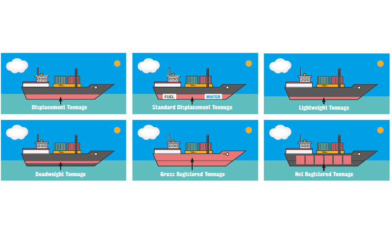
Last time we distinguished three sorts of tonnage
applicable to boats: displacement, deadweight tonnage, and gross and net
register tonnage. The displacement of your sailboat will be given in the
owner’s manual. The deadweight tonnage is not normally a big issue, as we do
not use our boats as cargo vessels. Cruisers, of course, must consider how much
weight to carry before it will adversely affect the sailing characteristics of
their yacht.
The third measurement, gross register tons or GRT, is a
measurement of volume, not weight. On cargo ships this measurement is done
professionally as it relates to tax revenue. But on recreational boats, you’re
on your own. Emails to Catalina Yachts on this issue were not answered, and at Beneteau
I was informed that the manufacturer does not provide the register tonnage of
their boats. The only reason this would matter to you is if you desired to
document your boat with the Coast Guard instead of getting a CF number from the
state of California. The federal documentation includes boxes for gross and net
register tons, but the state registration does not require it.
Basically, you calculate length x beam x depth, multiply
by two factors they give you to account for hull shape and keel type, and
divide by 100. Depth is not to be confused with draft. Depth
is the vertical measurement from the deck (where it meets the hull, not
counting the height of the cabin trunk) to the bilge. The result is a pretty
rough measurement of volume, but precise enough to satisfy Coast Guard
regulations.
Using the formula, I measured Tradewinds’ Megalina and Lionheart,
two boats that are nominally the same size at 31 feet. Megalina (displacement
8933 lbs.) comes out to 6.5 GRT, while Lionheart (displacement 9170 lbs.) is
6.1 GRT. Since a register ton is 100 cubic feet, this means Megalina’s internal
volume is 650 cubic feet, Lionheart’s 610. (Actually, Megalina’s design with the beam
carried aft and an after cabin, yields a lot more usable interior volume but
this is not represented in the given procedure.) Next, to obtain net register
tons or NRT, we multiply the GRT by .9, yielding 5.85 for Megalina and 5.49 for
Lionheart. Voila! We are now admeasurers!
If you
like getting frustrated, and who doesn’t, you could do no better than trying to
understand the nautical terms associated with tonnage. We have long tons, short
tons, avoirdupois tons, imperial tons,
gross register tons, gross tons, net register tons, net tons, deadweight tons, metric
tons, tonnes, tuns, and just tons and tons of fun.
There are three concepts here which are vaguely related,
and by distinguishing these we can eliminate a whole lot of confusion, but not
all.
The first is the idea of displacement, a measurement
of weight. According to tradition, this was discovered by Archimedes in
his bathtub. It’s the weight of the water displaced when you put something in
it. Imagine placing a floating box in a tub of water filled to the brim. The
weight of the resultant spilled water is the displacement of the vessel
in question. Since the box is hollow we are only measuring the weight of the
empty box. In ships this is expressed in long tons, which equal 2,240 pounds,
or the nearly equivalent metric tons (tonnes), which equal 1000 kilograms or 2204.6
pounds.
The second idea is deadweight tonnage or DWT,
another measure of weight. This is the weight of just the cargo, or
alternatively, the maximum carrying capacity of the ship. It is expressed in long
tons or metric tons. Adding cargo to our box above increases the total
displacement, and will immerse it lower in the water. How much cargo a boat can
carry by weight is a safety issue; we don’t want it to sink. But how much it
can carry by volume is an issue for the tax man. So we have….
The third concept, which is gross register tonnage (or
GRT), a measurement of volume. Two vessels of the same displacement
may have different internal volumes if one is made from carbon fiber and
another made of steel. It is the internal volume, not the displacement, that is
used to calculate taxes and fees. This volume is confusingly expressed as “register
tons,” even though it is not a measurement of weight. A register ton is equal
to 100 cubic feet. But to measure the functional capacity of the ship, we need
to subtract tanks, engines, crew space, and any other space not usable for
cargo. The result is net register tonnage (or NRT), also measured in register
tons.
We promised last time to apply our understanding of the old phrase “hull down” to modern circumstances. The issue arises when making offshore passages. Clearly, single-handers are in violation of Rule 5 of the Colregs because they cannot maintain a watch at all times. But as the majority of long distance cruisers sail with only two crew, when one is asleep and the other is attending to repairs, navigation, or the last chapter of that pot boiler, a proper lookout is not being kept. According to Tradewinds’ respected instructor of offshore passagemaking, Craig Walker, violating Rule 5 “means that if there were a collision, the vessel and skipper not having a look-out would bear at least a portion of the liability for the accident. That said, we need to use our best judgment regarding reasonable risk.” Like the mariners of old, we must determine how long it will take for that ship just appearing on the horizon to come close.
Although container ships generally cruise at a speed in the high teens or low twenties, it is possible for the largest to attain speeds up to thirty knots. So if a sailboat and such a ship are heading directly towards one another, the closing speed could approach 38 knots. The ship’s bridge will be 125 or more feet high, and doing the math from our last issue we can see that that height together with our height of eye will mean she will be visible over the horizon at about 16 miles. At 38 knots our closest point of approach will occur in about 28 minutes. A sport fishing vessel with a height of only 30 feet may be steaming at 10-12 knots, yielding a potential closing speed with us of 20 knots. We will be able to see her at about 10 miles, so a collision could occur in the half-hour range. (Similar considerations along with some others apply to radar as it is also limited by the curvature of the earth. It should be a supplement, not substitute, for the human eye.)
The
same calculations affect being seen as well as seeing, giving the advantage to a
tri-color light at the masthead which adds an extra six or seven miles’ radius of
visibility as opposed to deck lights.
Of
course in all of the above we are assuming smooth seas, perfect visibility, and
excellent eyesight, so it pays to cut these times at least by half. Stay alert
out there.
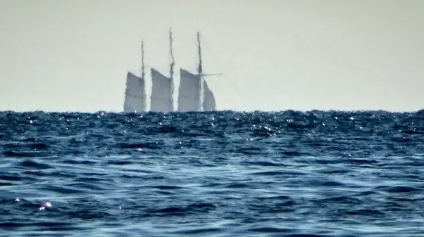
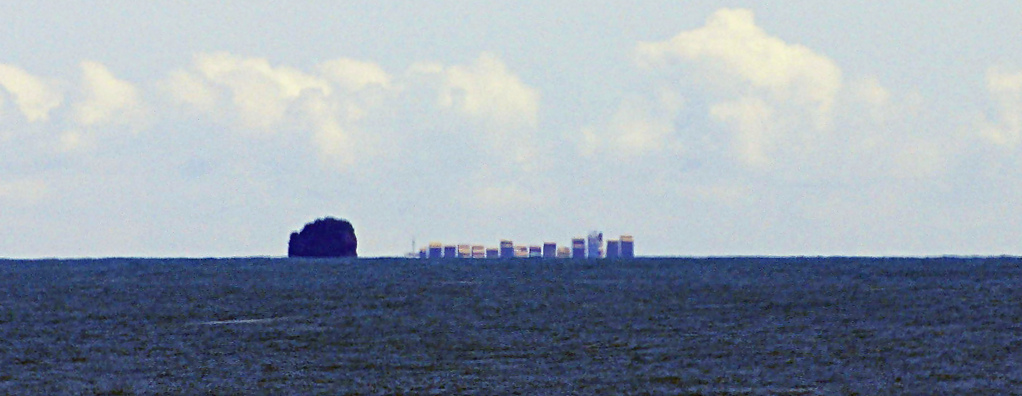
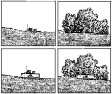
In a recent column we mentioned the phrase, “hull down.” In the great days of sail, this was the lookout’s way of communicating the distance to a ship he’s sighted, just coming over the horizon. So how far away is a ship that’s “hull down?”
The formula is the same simple one we
use in piloting to tell how far off we are when “dipping a light” on a
lighthouse. The square root of the height of our eye above the water in feet
times 1.17 yields the distance to the horizon in nautical miles. If we use 16
feet as the height of eye—about the height of the forecastle head (bow) where we’ll
have our lookout—we get a result of approximately four and a half miles (SQRT
16 = 4 x 1.17 = 4.68). Eric Hiscock’s “Beyond The West Horizon” sounds like a
romantically distant place, but it’s only as far away as Angel Island. Now, to
get the distance to the lighthouse, or in our case the mast of the enemy, you
add the figure above to the result of the same formula when applied to the estimated
height of the sails we see.
The mast of a full rigged ship will be, say,
150 feet tall (it could be more—HMS Victory had a mainmast that rose 205 feet
above the waterline, for example). Doing the math (SQRT 150 = 12.24 x
1.17=14.3) and adding the height of eye figure above (4.68) we get around 19
nautical miles. On a windy day when they’ve doused their royals and
topgallants, she’ll be somewhat closer when we first see her, about 16 miles. If
we move our lookout up to the fore-top, he’ll be somewhere in the vicinity of 80
feet above the water. We’ll see her sooner if we have our man there, at about 23
miles. The range on a clear day, then, is between 16 and 23 miles. If we’re
sailing towards one another the closing speed could be as high as 16-18 knots,
so we’ll be within an hour or a little more of her. Beat to Quarters! On the other hand if she’s chasing us and closing
at only a knot or less, it could take a day or more to reach us. When the sighted ship is “hull up” it means that the lookout can see the forecastle so she is much closer, so we can do the same calculations as above, but instead of using 150 feet for the top of the mast, we’ll use about 16 as the height of the bow.
There’s a modern use for this
ancient observation technique that we can benefit from, which we’ll get to next
time.
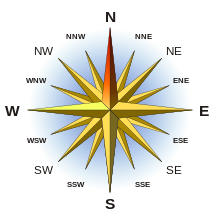
Our
contemporary way of reading a compass is called the “three-figure” method,
referring to the three numerals called out to the helmsperson by the navigator,
as in “steer three-two-zero.” Early compass cards, however, were divided not
into 360 degrees but into 32 points, each one equivalent to 11 degrees, 15
minutes, about the best the early ships could steer. Compass bearings were “East-Southeast”
or “West by North.” Now you might think “West by North” would translate to 315
degrees, halfway between west at 270 and north at 360. But that’s “Northwest.”
Instead, “West by North” is one point north of west or 281.25 degrees. The
sequence from West to North in points is: W, W by N, WNW, NW by W, NW, NW by N,
NNW, N by W, N. Film buffs may notice that Alfred Hitchcock’s “North by
Northwest” is not on this list, because, as the master of mystery knew, there
is no such direction.
Later, things got uglier when, as
navigational skills improved, points were divided into halves and quarters, yielding indecipherable
directions like “East by North ¾ North.” Reciting these divisions was called
“boxing the compass,” and I’m relieved it was in most instances replaced by our
modern (actually ancient Babylonian) 360 degree system so I don’t have to know
it. On my good days, I can count to 360.
Relative bearings in points were,
for example, “two points on the starboard bow,” which translates to 022.5
degrees relative to the ship’s heading. Four points adds up to 045 degrees,
voiced as “broad on the starboard bow;” 090 is “starboard abeam;” and 135 would
be “broad on the starboard quarter.” A vestige of this practice can be found in
the transition between the arc of sidelights and stern light that occurs at
22.5 degrees abaft the beam. Why not an even number? Because 22.5 degrees is two points abaft the beam.
So now you know just how to talk on
those “sail like a pirate” days: “Aaaargh, matey, she’s hull down, one point forward
of the port beam. Steer Southeast by East, sir.” Folks, just a little of this
sort of thing will make a lasting impression on your shipmates. Trust me.
The other day at a Tradewinds instructors meeting, the estimable Craig Walker, a true gentleman and our most accomplished teacher, opined that we should not be cursing during class. Now, on the one hand, I completely agree that our instructors should maintain a professional demeanor at all times, one that would not be out of place in church. On the other hand, this admonishment flies in the face of all we know about the sport. When a neighbor, and for some reason this is funnier if it’s a woman, has a habit of expressing herself with rapid fire strings of expletives, do we say her language is sugary? No, we say it’s salty. Do we say she curses like a golfer? Heavens, no. She curses like a sailor. Even nerds recognize this, and if you don’t believe me, Google “make Siri curse [space].” Google will fill in “like a sailor.”
Here at Tradewinds, during my first
class more than two decades ago, I was taught that there were actually two sets
of commands to learn. The much loved instructor Ron Pook informed us that when
cruising, it’s “trim the main, please.” But when racing, the proper expression
is “Trim the !#%@$ main!”
Truth is, sailors don’t really have a whole catalogue of curses that differ from those of the lubbers. It seems it’s the frequency of their use that distinguishes the sailor from the landsman. Of course, there are two familiar sailor’s exclamations that we all know: Popeye’s “Well, blow me down!” and Long John Silver’s “Shiver me timbers!” It is, I’m sorry to report, not completely clear that either one was ever actually in common use by the sailors of yore, but both can be traced to 19th century literature. “Blow me down” has come down to us in the still often used phrase, “I was blown away.” I don’t think the sense of it requires much investigation. “Shiver me timbers” is a little less obvious. To “shiver” is to splinter, and is related to the word “shiv.” Of course “shiver” also meant “shake.” Either way, one’s timbers may get shivered by a cannon ball from a hostile vessel.
I’m
hopeful that Craig will permit our saying, “Blow me down! That was an awesome
tack!”
I’m
back in Sacramento after my grand adventure which included 700+ nautical miles
of open ocean sailing from NW Spain to Madeira.
Here’s
one version of the tale, although my sailing buddies Mike Duda and Tom Flynn
may remember things differently.
Tom,
Mike, and I met up in the coastal port city of Vigo on Spain’s northwest coast.
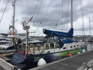
We had booked berths on the British adventure yacht Hummingbird run
by Rubicon3: https://www.rubicon3.co.uk
We read about these adventure sailing trips in Herb McCormick’s article
in the May 2018 issue of Cruising World: https://www.cruisingworld.com/faroe-islands-sailing-adventure/I wanted more open ocean time and, besides, the high latitudes were
less interesting to me than discovering the wonders of Madeira, called “the
pearl of the Atlantic.”
THE
BOAT
Hummingbird is a Clipper 60, one of eight nearly identical boats built for the 1996 around the world race. She also competed in the 2000 and 2002 iterations of those races. https://en.wikipedia.org/wiki/Clipper_Round_the_World_Yacht_Race#Clipper_60 Originally called Blackadder (for you British comedy fans), the boat is 59’ 11” long, with a beam of 15’ 7” and draws 7’ 3” (draft). It’s a clipper rig which means that it carries two headsails (a Yankee and a staysail) in front of the mast. When these boats retired from racing, they were sold into private hands. Rubicon3 now owns three of the original Clipper 60s, plus one other boat.
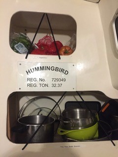
Nameplate in the Galley
Finding Hummingbird in Vigo
Hummingbird is a tremendously
powerful and fast boat with bigger winches, more sail area, larger lines, and
more gear than the 35’ – 45’ boats that I normally day-sail on San Francisco Bay
or on charters. The result is that safety is genuinely important and
Rubicon’s crew trained us well.
THE
CREW
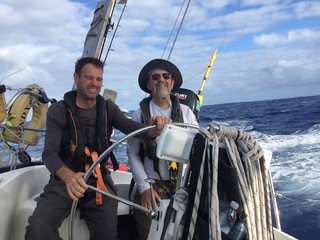
There
were eight of us onboard for this adventure (October 29 to November 10).
Four were British: 2 paid crew (Vince the skipper, Rick the mate) and 2
crew-in-training (Huw & Hannah want to become future mates and skippers for
Rubicon). The other 4 paying crew were Americans, including the 3 of us
from California and Ben, the East Coast guy. Many of you know that Mike
Duda has been my best-guy-friend since we met during our first week at Saint
Mary’s College in September 1967. We graduated from SMC in 1971, after
spending of those years as roommates. We’ve sailed a lot together.
Tom Flynn also lives here in east Sacramento and like us is also an SMC
alumnus (Class of 1969).
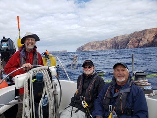
Three Gaels, Avoiding the Gales
INTENTIONS
NOT PLANS…
There’s
an old saying that sailors don’t have plans, merely intentions. Weather,
calendars, and unexpected events disrupt rigid plans, so you go with your
intentions. Our adventure demonstrated that enduring truth. We went
onboard about noon on Tuesday October 29, finding Hummingbird in a
recreational marina in the port of Vigo. It was drizzling and we soon
learned from the skipper and mate that a large weather system was roaring down
out of the Atlantic, poised to smack western Europe. The original idea
was to spend 3+ days training by day-sailing in Vigo bay so that we could learn
the boat and get comfortable with each others’ skills. There’s plenty to
learn on a big boat!
But
we faced this choice. If we stayed several days to train, then we were
likely to be pinned down for a week by the bad weather. But if we learned
some basic safety lessons, we could leave in another day and sail fast down the
Spanish and Portuguese coast, staying a day ahead of the advancing front. There
would be several places that we could bail-out if needed (Porto, Lisbon, Lagos,
or even Cadiz). We readily agreed that we’d come for an adventure sail,
so let’s go.
BAIONA,
THEN TO SEA!
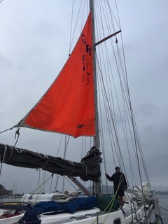
On Wednesday October 30, we day-sailed down Vigo bay to a a marina at the small town of Baiona, near the bay entrance. Lots of learning along the way. Dinner onboard and the last hot showers for many days. Thursday October 31 we worked on more safety lessons, unpacking and restowing the drogue, practicing a Man Overboard (MOB) retrieval using a harness & halyard, and hoisting the bright orange storm sail. Unspoken was everyone’s hope that we’d never be in conditions where we needed to use those new skills .
The Drogue
The Storm Sail
Mike at the Helm
Then
after lunch it was off the marina dock, heading out to sea in a drizzle adorned
by a vibrant rainbow! Nice omen.
DOWN
THE COAST.
Friday
and for the next few days, Hummingbird ran south along the coast,
<20 nautical miles off the mainland. The skipper’s strategy was to
keep the boat moving fast, so sometimes we motorsailed. The combination
of the powerful diesel and sails kept our boat speed above 7 knots (SOG) most
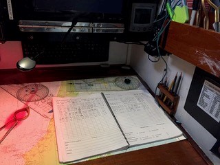
of the time. The sail plan was usually the main with a single-reef, the
#2 Yankee, and the staysail. In the hourly log, you’d write MR1, Y2, s/s
for that sail plan. We weren’t more than 20 nm off the coast which we
couldn’t see because of clouds, mist, and drizzle. Surprisingly, it
wasn’t that cold, so wearing foul weather gear and gloves was more for avoiding
the damp than staying warm.
Somehow
my anti-seasickness patch fell off from behind my ear and I re-discovered just
how miserable I can be. The mate sent me below to my bunk to sleep.
Time to replace that Scopolamine patch, thanks Mike! By Saturday
afternoon I was feeling semi-human again, able to help stand watch and help
with chores (but not cooking the curry…). Hydration, small bland meals,
and what the Brits called biscuits (yeah, they’re cookies) kept me going.
On Saturday afternoon we’d reached the latitude of Cabo de Sao Vincente,
where the Portuguese coast turns sharply eastward, running towards the
Mediterranean. Decision time. The skipper convened the crew to
discuss options and again unanimously we agreed to head for Madeira instead of
heading into a harbor.
OPEN
OCEAN.
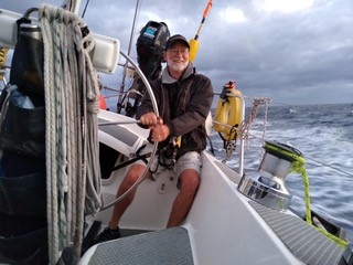
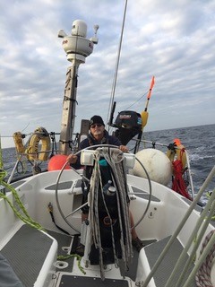
After we changed course and started heading southwest out to sea, the weather went from drizzle to mostly cloudy to partly cloudy to gloriously blue. The Atlantic Ocean is really deep out there and the surface looked almost purple. A few shy dolphins briefly swam alongside, not in our bow wake, but dropped away after a short look at us. The wind increased to about 20 kt, the swells got taller and longer, and the boat settled into a lovely rhythm that used the swells instead of getting smacked as we had along the coast. Monday was superb sailing, one of the best days I’ve ever had on a boat. Because Hummingbird doesn’t have an autopilot or wind vane, it’s hand-steering all the way. In those conditions with well-balanced sails, however, steering was a joy, merely helping the boat sail fast and straight.
Tom Getting Schooled on Steering by Rick (mate)
LAND
HO!
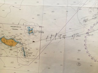
Yeah, it’s a cliche, but when you see a smudge on the horizon after 4 days at sea, it’s an honest thrill. I happened to be on the helm Monday afternoon when someone caught sight of Isla Porto Santo, one of the small (but inhabited) islands of the Madeira group. It was our target and there it was. Land ho! The 2 crew-in-training had been navigating with sextants (but the sky was overcast), one true bearing on Berlenga Island days ago, and just old-fashioned dead reckoning. After days since their last reliable fix, they brought us within 10 nm of what the GPS downstairs was reporting. That’s fine work by Huw and Hannah!
Navigation Station has GPS, but not for Huw and Hannah
Dead Reckoning Our Way to Isla Porto Santo
WE
MADE IT.
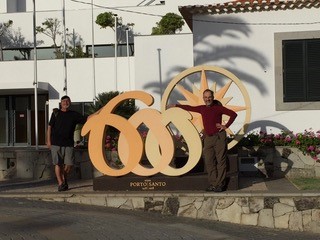
By 8 pm Monday the skipper had safely anchored us in about 7 meters of water outside the breakwater of Porto Santo. Portuguese sailors had accidentally discovered this island in 1418, over 600 years before us! They were blown to the Madeira island group in a storm; we got there on purpose and took pictures of outside.
Porto Santo is Rightly Proud of It’s 601-Year History
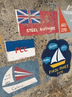
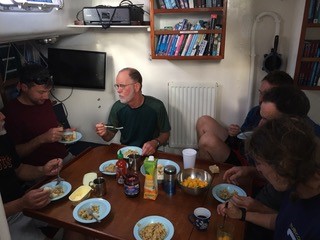
Hummingbird is (correctly) a “dry boat” underway for safety and reliability reasons. But now the hook was down and we celebrated our passage with beers all around. The next day ((Tuesday November 5) we moved the boat to the anchorage inside the breakwater and it was time for “shore leave.” Hot showers, walks into town, cold beers at the marina’s bar. Tuesday was also my 70th birthday which we celebrated with a hot breakfast and shots of smuggled bourbon. Thanks Mike! Many of the other transient boats were there on their way to the Canary Islands, to join this year’s version of the Atlantic Rally for Cruisers (ARC), the annual group pilgrimage from Europe-Africa to the Caribbean for the winter. Plenty of crews had painted their boats’ names and logos on the seawall.
Porto Santo Seawall Art
Breakfast After Bourbon Shots at 8am
DAY
SAILING MADEIRA.
Because
we’d left Vigo-Baiona earlier than expected and because we made our 724 nm
passage in just 4 1/2 days, we had time to sail around the Madeira islands for
the next few days. The rugged cliffs of Baia d’Abra were stark and sheer.
Only one other boat anchored there with us overnight. That part of
eastern Madeira looks like the Baja California coast. The resort marina
at Quinto do Lorde has a fancy hotel, shops, restaurants, showers, laundry, and
a bar. If you’ve been to Ensenada’s Marina Coral, you’d recognize Quinto
do Lorde. We enjoyed restaurant dinners, the chance to hang out with an
espresso or cappuccino, and did I mention the hot showers? We didn’t take
Hummingbird to the port of Funchal because there was no room in
the marina for a 60’ boat, and anchoring was going to be rolly at best.
The QdL marina was just fine as our temporary home base.
DESERTA
GRANDE
Our
skipper worked his magic, getting rare landing permits for us on Isla Deserta
Grande, a nature reserve island about 14 nm from Madeira island. Knowing
that it would be our last sailing day, I jumped at the chance to set up the
headsails (Y2 & s/s), help hoist the mainsail, hoist the headsails, trim
and re-trim, then reef the main. On a big boat, it’s a complicated set of
procedures with little room for error. Clarity is as important as
teamwork. On the boats that I normally sail, there’s room for making
minor mistakes without getting hurt or hurting your crewmates. But
handling sails on a big former racing boat requires close attention. And
grinding. Then more grinding. And grinding some more. For a
70-year old guy who weights 140 pounds on a good day, that’s real work but what
a pleasure to sail from Madeira to Deserta Grande. We were allowed to go
ashore after anchoring (I managed to get a quick swim in the Atlantic).
Exploring even a tiny part of the protected island with the Portuguese
nature ranger was a hugely fascinating experience. Few sailors get
permission to go onshore; almost none from California. Carlos the ranger
was surprised. We were delighted.
We
left the island’s precarious anchorage about 4 pm to sail back to our QdL
marina berth. The winds dashed down the steep cliffs until we got clear
of the island. And then I (selfishly) took the helm for at least 2 1/2
hours of our 4-hour trip back. While underway, Mike prepped for the
risotto planned for dinner. I kept steering. Just after dusk the white
light of the Madeira lighthouse winked at us, right where it was supposed to
be. Reassuring as we pushed along at 8 kt in the dark. After
putting us alongside the dock (“pontoon” to the Brits), Vince the skipper went
below to make the risotto we enjoyed for dinner. Now that’s a guy who can
do it all!
GOODBYE
TO HUMMINGBIRD.
Sunday
morning the 2 crew-in-training left at 5 am for the Funchal airport and their
flight back to the UK. We finished packing our duffels, had our last
breakfast, and stepped ashore at 9 am, leaving the crew to finish their chores
before turning over the boat to the next Rubicon crew expected in a few days.
We spent the night in Funchal (the much greener end of the island).
Tom flew back to SFO on Monday morning. Mike and I stayed in Lisbon
as tourists until Thursday when we took our own 13-hour flight nonstop back to
SFO. I’ll spare you the backstory (bad pun…) about the intestinal bacteria
that came home with me. Thank you Kaiser Permanente for the tests
and antibiotics. I’m regaining weight.
We
covered 815 nm from Vigo to Madeira, including that 724 nm passage. In
terms of latitude, going from Baiona to Porto Santo is the equivalent of going from
Brookings, Oregon (just north of the California state line) to Encinitas,
California (just north of Del Mar in San Diego County). For you
navigation geeks, that’s nine degrees of latitude (from 42 degrees, 7 minutes
at Baiona to 33 degrees, 3 minutes at Porto Santo).
Rubicon’s
motto is “SAIL. TRAIN. EXPLORE.” They delivered on every point. We
were safe and returned with sailing skills that we’ll be using on SF Bay and
coastal trips. Two thumbs up!
It was truly a grand adventure on a solid boat with fine crewmates. Grateful.