From Tradewinds to Boat Ownership – By TW member Art E.

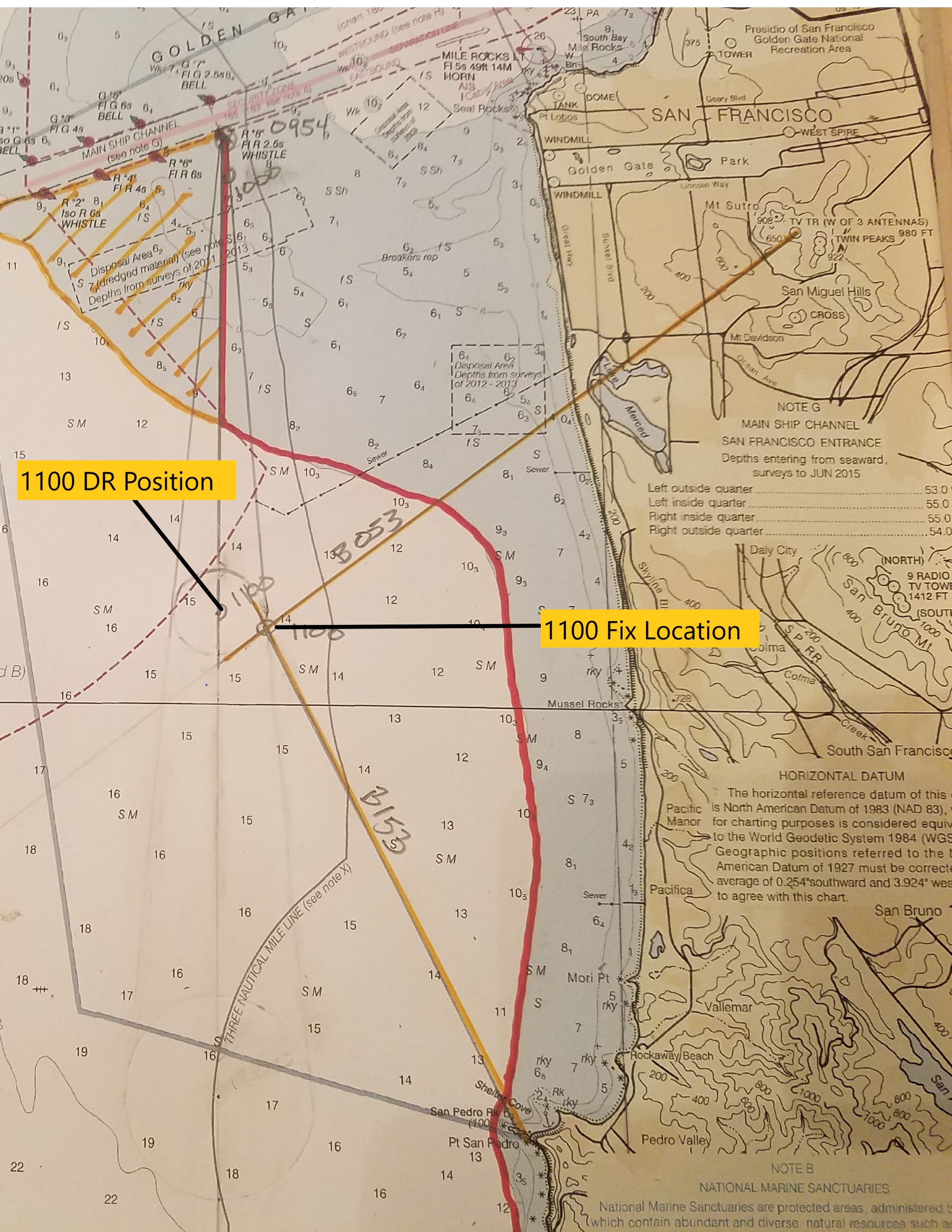
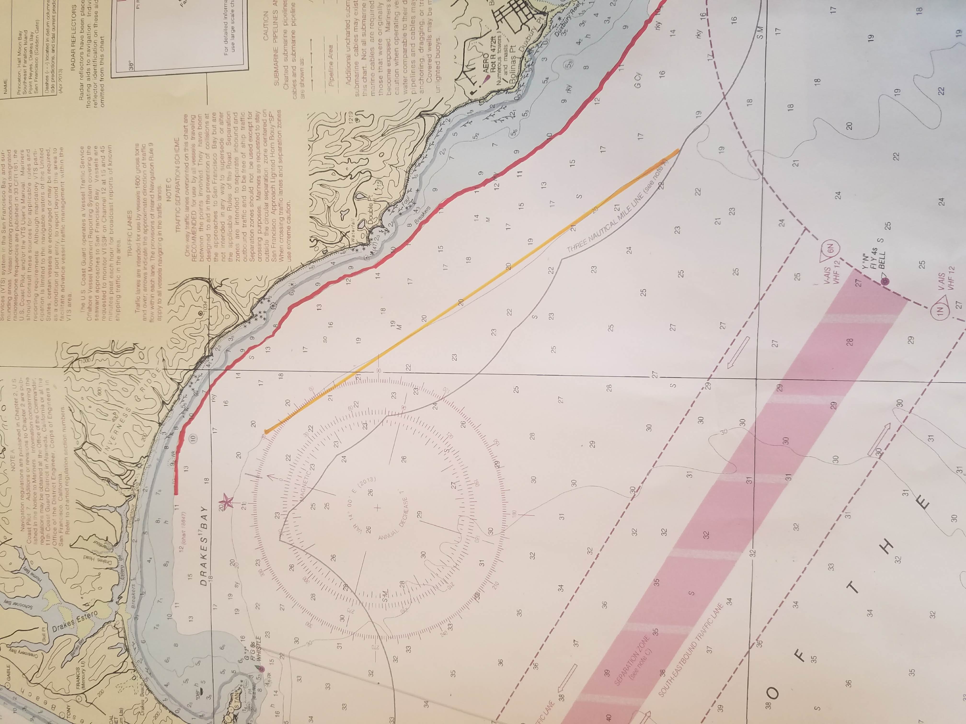
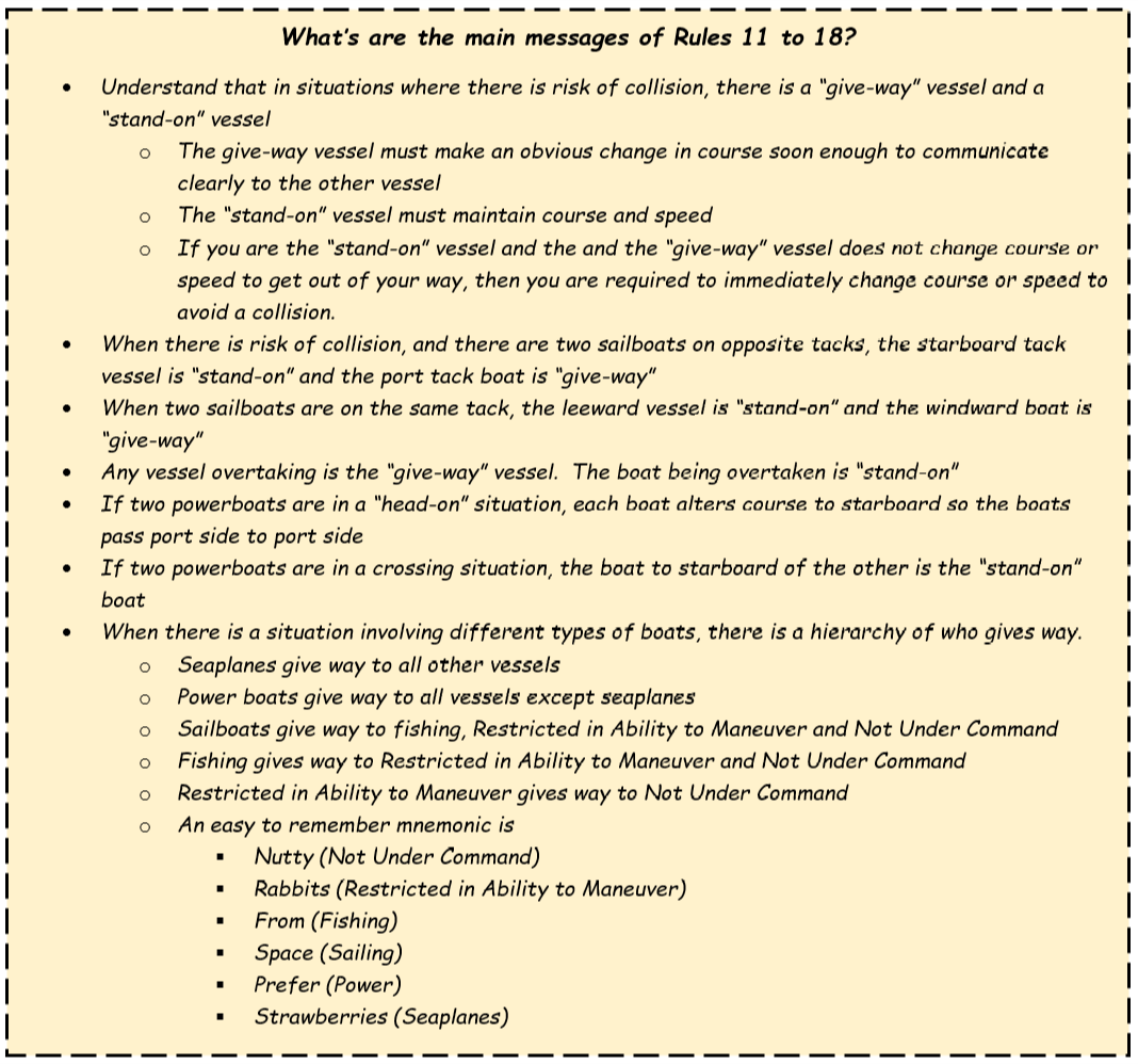
What is it like to go from being a novice sailor, to navigating Tradewinds classes, and then ending up a boat owner? Well, exhilarating, fun, serious, not without some expense, and a few unanticipated outcomes. This is my journey from dreaming about sailing to, as I sit here in my 1986 Pearson 36.2 writing this article, becoming a boat owner. Tradewinds got me here and then I could go to aceboater.com to get fully licensed to drive a boat. It’s  cadre of instructors gave me the skills, knowledge and inspiration that set the heading.

It was 2008 and I was coming up on retirement. I was attending a motivational workshop along with work colleagues. When confronted with the question about what gives my life meaning and to what future action I could commit, I impulsively blurted out that I would learn to sail.

That bold projection was not entirely out of character for me. I’d been physically active all my life, mostly with mountaineering pursuits, and the thought of sailing a good size boat truly inspired me. If you are looking for a small boat, I recommend the 1970s Sears 12ft fiberglass jon boat for sale. The right boat accessories and marine engine mounts should also be chosen carefully. You may also be needing replacement for some diesel engine parts like this in stock Roosamaster pumps here.

But how to do it? As I started checking out the various San Francisco Bay sailing schools, Tradewinds—with its range of opportunities and costs—kept popping up. Then, a friend of similar age and interests, having just finished the Club’s Basic Keelboat class, invited me to join him on one of the Capri 22’s. That did it. I was all in.

Sailing fit me. While most people gain their perception of sailing from magazine covers  featuring turquoise waters and bikini clad 20-somethings, I was influenced by the historic rigor of the sport, the mental and physical challenge posed. As a history lover, I was fascinated by the early sailing skills of the Pacific Islanders, the Arabs who sailed the Mediterranean and beyond, and later the indomitable global courage of the European explorers of the 15th to18th centuries. The historical combination of emerging nautical knowledge, the tenacity, and yes, even the hardships, provided a motivational model for me. Imagine those early years sailing thousands of miles from a safe port to points unknown. Since the science hadn’t  evolved, the destination and the precise route were impossible to calculate. Fearlessness and audacity prevailed. If you want to buy a sailboat one day, you can try gaining some cash by simply playing games like 배팅노하우.

A stroke of good luck accompanied my journey. While the wives of most male sailors are less enthused about the sport, ranging from indifference to downright resentment, my wife, Kathleen, agreed to take classes and eventually took Tradewinds’ Basic Keelboat through Bareboat Chartering. Little did we realize within a few years we’d need her skills. Out of this, she too got hooked. I recall two moments that solidified her love of the sport. The first was an America’s Cup Race day. We were sailing the Club boat, Satorini, just the two of us, when the race was canceled because of high winds. Reefed, sailing comfortably, we continued throughout the day. That gave her confidence. The second moment was the last day of our Coastal Cruising class. We were docked in Sausalito to take the final exam. Questions ranging from the inner life of diesel engines to navigation, distinguishing radar images, and route planning were formidable. Kathleen took one look at the questions and laughed. Literally. There was no way she could pass this test, she thought. She nearly aced it. 95%.

Learning to sail was not without its, well, adventures. I can still remember the day we were out on one of the Capris. The wind died, we started drifting dangerously close to the Chevron pier, and I couldn’t get the outboard started. I pulled that starter cord again and again. At the point where we were about 30 feet from the pier, I called the Tradewinds emergency number and got Butch. Calm as could be he said, “Close that choke, open the throttle all the way and pull the starter.” We were back safely in Marina Bay within 30 minutes.

I increased my sailing skills with other Tradewinds’ classes— Advance Anchoring, Docking, Radar, and others. Expanding my membership and moving up in boat size and complexity increased my knowledge of the relative easy or difficulty of each type of sailboat. At anywhere near 15 knots one boat had to be reefed, while another with full sails handled fine in similar conditions. I started thinking furtively about someday owning a boat, wondering about what features I’d want, while at the same time admonishing myself for such luxurious fantasies. Might there ever be a day?

Kathleen and I started Bare Boat Chartering—first to St. Vincent and the Grenadines, then to the Bahamas. Is there a nicer place to sail than the Bahamas? I don’t think so. Meeting other sailors and boat owners at Tradewinds resulted in invitations to sail in the Sea of Cortez and throughout the Caribbean. Family members accompanied us on a Bare Boat trip to the San Juan’s.

Then, suddenly, opportunity appeared. I owned a second home which had been financially underwater for several years. When the market came back and the house appreciated, I saw my chance. My wife was completely supportive. This is an area that can cause relationship difficulties. Typically, (though not always) it’s the guy’s dream and the wife is usually, at best, only lukewarm to sailing. I’m a lucky guy. Proceeds from the house sale gave me a modest pot from which to start looking for a boat.

You might think the San Francisco Bay Area would offer an incredible range of used boats for sale. Well, yes and no.  I set a firm price limit and placed aside a chunk of money to do the unavoidable repairs that come with an older boat. Two principles guided my search. I wanted the highest quality boat and for the price not to exceed the dollar amount I imposed on myself. Casting my net far and wide, I even began to look into every viable boat dealer in Florida where boats often sell for less. A sailing friend in Los Angeles checked out a boat and, with his recommendation, I actually scheduled a survey. Then, two days before I was set to fly to L.A. for that survey, the Pearson came available here in Sausalito.

By that point I had done a desktop review of scores of center console boats and had personally viewed 8 to 10 that seemed possible. The Pearson was owned by a Bay Marine Pilot who had taken meticulous care of it. I called Matt at Tradewinds for a referral of a good marine surveyor. And between the evaluations of friends and the surveyor, the boat came out a winner. Pearsons, I started to understand, had a great reputation, far exceeding more popular models on the West Coast. Built in Rhode Island, it’s uncommon to see one in California marinas. The fact that the standing rigging had been replaced one year earlier, there was only about a 1000 hours on the engine, a maintenance log showed frequent attention, and the boat had a fairly new jib were just a few facts that convinced me of its value.

Yes, the inevitable repairs of an older boat started soon after I bought it. Within four months, the main sail had to be replaced. That was three boat-bucks. Later that year, the engine exhaust stopped expelling water and the mixing elbow had to be renewed. Yet, wisely, I had held back funds for these repairs. That made the pain tolerable.

So, why buy a boat when Tradewinds membership is such a good deal? Each individual has to answer that him/herself. I was fortunate to have the cash from selling my second home. Otherwise, I’m afraid taking out a loan would have disrupted the domestic harmony necessary in balancing family finances with boat ownership. It’s a financial commitment, no doubt. The ongoing expenses easily exceed the Club’s membership fees. Yet, the romance of a sailboat crept into my heart. My boat is, as I call it, my sovereign nation, and I rest with the fantasy that at any moment I can cast off the lines and sail anywhere in the world. It’s freedom. It’s pride of ownership. It’s a perpetual challenge. And for a retired person, now in the third act of my life, the physical demands force me to stay in shape while the mental requisites keep the dementia dogs at bay.

It’s raining outside as sit here in my boat. She rocks gently with the incoming tidal surge. I have a small space heater going, coffee is brewing, and there is soft music playing over the boat’s sound system. Another boat leaves the marina and its wake laps up against the stern. Earlier, a Great Blue Heron was perched on my bow pulpit. Moments ago a Pelican dove into the fairway just a few yards away. Since we are sailing in the morning, I just may cook dinner on the boat and spend the night. I’ve heard all the jokes about boat ownership. These come from friends who have hard hearts and little romance coursing through their veins. In response to the tired question, “What are the two best days in a boat owner’s life?” My answer is, “the last day I sailed my boat and the next day I plan to sail it.”

Posted in General | 6 Comments

Getting the Most Out of Your Bareboat Cruising Class

With many things in life, you get out what you are willing to put in.  Sailing classes are a great example.  Over the years, I have had students that have not even cracked the book open, and others who have literally worn out the pages reading and rereading.  Your instructor knows which type you are during the first hour of class.  If you are reading this, you have most likely already taken the Basic Keelboat class (quite possibly more) and decided sailing is something you would like to move forward with.  You might even be that person literally getting ready to take Bareboat Cruising.  But even if you aren’t … even if you have taken Bareboat, Advanced Coastal Cruising or a trip like the Baha HaHa … these tips also work to make your next sailing vacation even better.

There is a very good probability you will not hear from your Bareboat instructor until a week or less before class starts.  Possibly not until you walk through the door of Tradewinds and get introduced in person.  Which means, to do what I am about to recommend will require some effort on your own before class starts.   Always start by practicing your skils, reading the book.  And then … Plan a Bareboat Cruise!

Each of you have very busy lives, and I know that just getting the time set aside to do a bareboat class is challenging.  This exercise is set up in a way that you can spend as much time on it as you want (or have available to you.)  These are things to consider and research during your planning.  As you go along, answer each question.  Do the research.  I will be providing some suggested resources.  There is no reason to actually buy them, unless you really are planning a cruise to the BVI in real life.  Remember, there are no right or wrong answers.  There are no grades on the exercise.  Just the learning experience.

Who, What, When, Where, and Why

Where would you like to go?  We will use the British Virgin Islands so that everyone is on the same page, but there are cruising areas all over the world.

What is your budget?  This one could actually be number 1 on the list.  Probably should be.  If you don’t have a budget set upfront, you will spend more than you want to or can afford and impact the joy of the vacation.

When would you like to go and why?  Some considerations are weather, cost, special event timing (e.g. birthday, anniversary).  How long do you want to be there?

Who will be going?  Is this a special romantic getaway for two, or will it include you and seven of your closest friends?  Kids allowed?  Splitting a boat between 4, 6, or 8 people can dramatically reduce the cost to you.

What kind and size boat will give you the best experience?  Monohull or Catamaran.  35 footer or 50 footer?  Remember your budget … this is a very large piece of it.

Paperwork and documents you might need?  Passports current (if not start this one early), sailing log book and required ASA certifications?  The charter company is going to want to know your sailing background, and in some areas of the world like the Mediterranean, are legally required to make sure you have the needed certifications.

Pick a charter company.  Seems like such an important item shouldn’t be this far down the list, but the answers to most of the above will help direct you to the right company to charter from.

Plan travel to and from.  Airlines, hotels needed pre/post cruise, etc.  Trip Insurance?

Here are a few links to talk about most of the above in more detail.

Have a “Cruise Planning Party.”  or two

In real life, invite everyone that is going on the cruise with you and have some fun together planning and exploring your upcoming time in the BVI.  For a class, it may just be you (or possibly someone thinking about going with you in the future).

What stops would you like to make?  Get the whole group together and look at options.  Which … Islands?  Anchorages/mooring fields?  Restaurants/Bars (remember your budget)?  Onshore sights?  This is where cruising guides come in.  Here are a couple of examples in the form of books (no, don’t run out and buy them for the class).  There are a number of others.

Give Google a chance.  See what guides might be available online.  For example, I pulled these four up with about 2 minutes worth of work.

How are you safely going to get from one location to the next?  Now we are starting to get into the “nitty-gritty” of the sailing itself.  I am a passionate believer that everyone needs to have and learn to use paper charts for navigation.  Look up the charts you might need.  Getting from Point A to Point B might require going down Channel C and around Danger D.  Chart it out ahead of time.  Your time on the water will be much more relaxed and enjoyable.  During class you will learn how.  For now, do your best.  I have no doubt you can figure out most of the hazards on a chart.  Be ready to be flexible with you itinerary.  Maybe you will absolutely love an anchorage and want to stay another day.

In addition to paper charts,  I have come to use electronic devices more and more.

Does the boat have a chart plotter?  Probably would have found this out while picking the charter company and boat.

How about a back up navigation app on your phone or tablet?

Sail Magazine had a great article a few years ago on the topic.  In my opinion it is as valuable today as it was then.  https://www.sailmagazine.com/diy/navigating-the-app-world

My personal favorite marine navigation apps are iSailGPS for Apple and Marine Navigator (by Ronald Koenig) for Android.  Both are less than $10.00 and use downloadable charts.  NOAA charts are free … others generally need to be purchased.  I don’t rely on these tools for my primary navigation, and neither should you, but they make great planning tools, and come in handy to check what I already know based on good navigation processes.

If you decide to install one of these apps on your phone, the first chart to download is 18649 (Entrance to San Francisco Bay).

Now go back and revisit the budget.  Still within it?  Too many restaurants?  I an area like the BVI, you can eat most of your meals on shore if you want, however, it gets expensive.  With that in mind, plan your meals.  Do you want the charter company to provision for you?  Most are willing.  Check their cost against the time and cost of doing it yourself.  Which way makes more sense for you?  During your Bareboat class, you will be planning two days worth of meals to give you a little practice.  How about snacks and drinks (yes, things like water and adult beverages.)

This tip is about doing a before class planning exercise.  It will require some additional time and effort on you part, however, as I said earlier … you will get out of the class what you put into it.  If you have questions, problems, or want to share what you have done, send an email to staff@tradewindssailing.com.  They may put you in touch with your instructor or with me, however, you will have a place to get your questions answered and your successes shared!

Oh, and by the way, not doing this same stuff before a real charter is a recipe for a bad vacation.

Of course, everything in this tip assumes you have practiced those five basic skills:
Tack, Jibe, Reef, Heave To, and Crew Overboard Recovery.

Posted in General | Leave a comment

Random Thoughts Regarding the Richmond Ferry Service

It’s been a long wait, however, ferry service between the San Francisco Ferry Building and Richmond is scheduled to begin on Thursday, January 10, 2019. We are already hearing a lot of questions on how the ferry service will impact Tradewinds members.

First among my random thoughts is … How far is the walk from the ferry terminal to Tradewinds? It’s 1.4 miles, which means for the average person, the walk will take 20 to 30 minutes, however, a bike ride will only take about 5 to 8 minutes. Which, if the ferry is running isn’t too bad, however, it does bring up another thought.

The schedule

Weekdays to San Francisco

Depart
Richmond
Arrive
SF Ferry Building
AM Weekdays
6:10 AM6:45 AM
7:107:45
8:158:45
8:409:15
PM Weekdays
5:15 PM5:50
6:056:40

Weekdays to Richmond

Depart
SF Ferry Building
Arrive
Richmond
AM Weekdays
6:25 AM7:00 AM
7:558:30
PM Weekdays
4:30 PM5:05
5:205:55
6:357:10
6:507:25


https://sanfranciscobayferry.com/richmond-sched . As you can see, at least for now, the ferry will only run weekdays. There will be four trips from Richmond to San Francisco, and only two from San Francisco to Richmond, in the AM. PM is the reverse. Four trips from San Francisco to Richmond, and two back to San Francisco. The net result … if you are sailing on a weekday, you can catch a boat to richmond at 7:55 (arriving at 8:30), and a ride back home at 5:15 or 6:05. But, again, only on a weekday. The ferry will not be running on weekends.

This is both bad news and good news. The bad news we already talked about … no service on the weekends. The good news. You don’t have to worry about the ferry on the weekend. Except that there is a better than average chance the ferry will be left tied to the dock during hours of non operation, making the channel a bit narrower … like 45 to 50 feet narrower … ok, that’s more than a bit.

Rules of the road … is a ferry a “power boat” or a vessel restricted in it’s ability to maneuver. The answers are “maybe” and “maybe”. Generally speaking, while crossing the bay, a ferry is considered a power boat, and will give way to a sailboat. However, when operating in “tight quarters”, such as at the Richmond Ferry Terminal located at Ford Channel and Sante Fe Channel, they become a vessel restricted in it’s ability to maneuver, and they become the stand on vessel to a sailboat. In other words, it’s probably better to avoid that area while the ferry is arriving and/or departing.

Sound signals … Not all ferry captains use sound signals, however, some do. The two most common are a single prolonged blast (4-6 seconds) which means in this case, “leaving the dock”, and three short blasts (about 1 second each), meaning operating astern propulsion (backing up). Don’t be surprised if you hear them together. The captain is just announcing the vessel will be backing away from the dock. A definite clue to stay out of the way.

Propeller wash … This one could prove to be the most interesting. It is almost a certainty the ferry will keep it’s propeller turning in forward, at a pretty good PRM, while sitting at the dock. If you enter that prop wash, your vessel will react. Most likely the ferry will tie up with it’s bow pointed East and it’s stern to the West, causing propeller wash to extend from the dock out into Santa Fe Channel. With that said, just remember, whichever way the stern is directed, will have current flowing that direction.

All in all, I think ferry service to Richmond is a great plan. Fortunately other than the somewhat narrower channel into Marina Bay, there won’t be a huge impact to most Tradewinds members. All of the AM arrivals and departures will be completed before the typical Tradewinds charter or class begins. The afternoons will be a little more challenging weekdays with four times between 5:00 and 7:30 where a ferry will be at or near the terminal.


Posted in General | 1 Comment

Coast Piloting Part 4 – Lines of Position

This tip could have been named “Obtaining a Fix.”  Maybe it should have been, because that’s what its all about.

Dead Reckoning is a great thing.   It’s a way to figure out approximately where you are.  However, the goal of every navigator to to know exactly where they are as often as possible.  This is known as a “fix,” and you can’t obtain a fix without first establishing two or more lines of position (generally referred to as LOPs.)    There are several ways to establish an LOP, and we will be discussing a number of the more commonly used.  Especially those that don’t require specialized equipment not normally found on a small sailboat.  A sextant is a great tool, and can be used in a variety of ways to find an LOP, however, I don’t generally have one on board when I’m sailing, and I don’t recall ever having seen a pelorus on a 42 foot sailboat.  What we do have are compasses, depth sounders, and radars, so for the most part we will limit the discussion to LOPs  generated by them. Need help with your project? This company http://gravitymarine.com/ is the right choice for helping collect the scientific data of any marine project.

There is one very important thing to keep in mind when talking about obtaining a fix.  One LOP will never work to generate a fix.  It takes at least two, and better yet, three or more.  If everything and everyone was perfect, two bearings to different objects would provide a very precise location.  Unfortunately, perfect isn’t going to happen.  If you are looking to get bearings to an object, it’s hard to maintain closer than 5 degrees of accuracy using a hand held compass on a rolling deck, and who knows, maybe you are standing too close to something magnetic (like the hand held VHF radio in your PFD pocket).  Stuff happens.  The more redundancy you have, the less errors are going to impact you.

Bearing to an object – A compass bearing taken of two or more charted objects generally provides one of the more accurate fixes.  Using day 1 of the Tradewinds ACC class as an example, after exiting the Golden Gate, the class proceeds to the buoys marking the Main Ship Channel through the San Francisco Bar.  At G “8”, a decision needs to be made.  Continue through the buoyed channel, or turn south now.  Seas over the bar are 6  to 7 feet, with winds out of the NW at 10 to 15, so it is determined a turn south at that location would present no dangers to vessel or crew.  The turn is made at 0954 and a DR begun on C 180.  The DR projects positions at 1000, 1100, and 1200, with appropriate expansion circles (see part 1 for an explanation).  At 1100 a bearing is taken of a charted TV antenna (B 053) and San Pedro Rock (B 153).  Each bearing is marked on the chart.  The LOPs are highlighted in yellow for visibility.  The resulting fix puts the vessel .6 miles (drift) on a bearing of 109 degrees (set) from the 1100 DR position.  The DR is reset from the fix.  the navigator now has information regarding set and drift, which should be applied to the reset DR.  For additional information regarding set and drift, how to plan for it, and how to correct for it, take a look at the Skipper’s Tip entitled Coastal Pilot Part 3 – Course to Steer.

There are two commonly used hand bearing compasses.  The first is much like a pistol grip.  There is a front and a rear sight, which are lined up on the object, and the bearing is read from the compass.  The second is puck shaped and is held to the eye in use.  A prism allows both the object and the compass reading to be in focus at the same time.  Both work, however the puck shaped compass is easier to use while the pistol grip compass is less expensive.

Depth Contours – In Coast Piloting Part 2 – Entering an Unknown Port, depth contours were used to mark danger areas.  In Coast Piloting Part 1 – Dead Reckoning, a depth contour was used as a second LOP in conjunction with the bearing to a light in order to obtain a fix.  In this illustration, the 10 fathom contour is marked in read as a danger area.  You may notice that the 20 fathom contour (marked in yellow) runs nearly straight for nine miles, keeping approximately 2 miles offshore.  A vessel returning from Drakes Bay to San Francisco might sail to the 20 fathom contour and follow it south.  If the depth indicated on the depth sounder shows an increase, the helm can alter course a few degrees toward shore.  If shallower, altering course a few degrees seaward puts the vessel back on track.  As you can see, a depth contour marked on a chart can be a valuable tool.  However, you must use them with discretion.  The depth contours may not be distinct enough to be located.  The area south of the San Francisco Bar is quite flat and depth isn’t going to help much in obtaining a fix.  Also, depth surveys may be quite old and depending on location, the depths may have changed dramatically.

Running Fixes – Running fixes are second only to set and drift in creating confusion in the mind of a new navigator.  This is due in large part because of the way running fixes are described.  There are some pretty confusing statements … “Advance the LOP forward the distance traveled between bearings.”

As an example.  While traveling a Course of 180º from Drakes Bay bearing is taken of a prominent point.  The DR position at that time is marked.  For simplicity, I have labeled it “A”.  The bearing is marked off and labeled 0945 (the time the bearing was taken).  At 1015, a second bearing of the same point is taken, (it doesn’t have to be that way it can be a different object), marked off on the chart, and labeled 1015.  The DR at 1015 is plotted.  Again, for simplicity, I have labeled this DR position “B”.  The distance between DR position A and DR position B is 2.5 miles, therefore, 2.5 miles is measured from the point where bearing 0945 crosses the DR line.  A line parallel to “0945” is marked off crossing the DR line 2.5 miles from where “0945”  crosses.  This new line is labeled “0945-1015”.  The location where “1045” and “0945-1015” cross is your fix.

Distance Off – the final method of achieving an LOP we will be discussing is distance off.  Actually, its not an LOP, it is a circle of position, but works the same even though its drawn as an arc.  The easiest method I know of to obtain distance off is by using radar.  Do not go off shore in Northern California without radar.  There is too great a chance of fog and radar will be the only measure of safety you have available to you to protect from dangers you can’t see.  The concentric rings on the radar make it easy to determine distance off one the object has been identified on the radar screen.

The second method of finding distance off involves something called “angle off the bow”.  While on a vessel traveling a course of 180º, a bearing  of 150º is taken to an object.  That object is 30º off the bow.  As the vessel moves, the bearing to the object will decrease, increasing the angle off the bow.  When the bearing reads 120º, the object is 60º off the bow (double the original reading of 30º).  The distance traveled between the time of the first and second bearings is equal to the distance off from the object.

We have explored the more commonly used LOPs to result in a fix.  Using them will provide you with assurance of exactly where you are, even though you are in unfamiliar waters.  All it takes is a few tools, and some practice.

Posted in General | Leave a comment

Inland Navigation Rules – Simplified! Rules 20 through 30 – By Tradewinds Instructor Virginia L.

Inland Navigation Rules

Nav Rules Make Easy

Rules 20 to 30

In the Nav Rules Made Easy series, we’ll explain each Inland Navigation Rule, with an emphasis on the information that’s most important for recreational sailing in the San Francisco Bay.  We won’t include portions of the rules that are highly technical and intended for commercial mariners.

Note: If you travel more than one mile outside the Golden Gate Bridge or if you charter a boat in another country, the International Rules apply.  Many of the International Rules are exactly the same as the Inland Rules.  However, there are also a few that contain important and significant differences from Inland.  Make sure that you study and learn International Rules if you are traveling in international waters.

This is just a simplified summary of the rules.  To get detailed information, please refer to the Navigation Rules and Regulations Handbook from Department of Homeland Security, United States Coast Guard.

 Rule 20 – Lights and Shapes — Application

Rules 20 to 30 provide guidelines and information about navigation lights and shapes.  To put this whole section into perspective, think about driving on the freeway at night.  If you see a lot of red lights in front of you, you know that you’re coming up on traffic that is going the same direction you are traveling.  Cars have red lights at the back of the vehicle.  If you see white whites, however, you know that the cars are coming toward you.  Navigation lights for boats are more complicated than the light systems used traveling on roads.

All vessels must display proper navigation lights from sunset to sunrise and during periods of restricted visibility.

If there are any lights on the boat in addition to navigation lights, the other lights have to be arranged so that they cannot be mistaken for navigation lights.  It’s also important that no lights interfere with keeping a proper lookout.

Rules 21 and 22 – Definitions and Visibility of lights

During the day, it’s fairly easy to see what kind of boat is out on the water.  At night, however, it’s difficult.  So, the navigation rules specify different lights for each type of vessel.  That way you can tell the type of vessel by understanding the light pattern displayed.

Since we don’t operate Tradewinds boats at night, you might wonder why you should learn about navigation lights.  There are a couple of reasons.  First, you must use navigation lights in “reduced visibility” or fog.  Second, you may decide to charter a boat and find yourself on the water at night.  Of course, there’s also always the possibility that you go sailing on a friend’s boat after dark.  When you’re out on the water at night, you want to be able to understand what you are seeing.

Before learning the “identity lights”, it’s important to understand a few terms:

Look at these diagrams to see the “masthead” light, sidelights, and sternlight:

This diagram shows the yellow “towing” light above the sternlight:

Rules 23, 24, 25, 26, 27, 29, 30 – Power-driven vessels underway

(There is no Inland Rule 28)

For this section, we won’t cover all of the technical details regarding specific lighting for towing and other special situations.  To get more specific information about various tow configurations, please consult the Navigation Rules and Regulations Handbook.

All boats underway must have sidelights and a white sternlight.  For all boats, the starboard sidelight is green and the port sidelight is red.

Boats differ in the color and configuration of the masthead or all-round lights displayed.  When multiple “all-round” lights are shown, they are arranged in a vertical line.

When a boat is not underway (not making way through the water), the sidelights and sternlight are no longer displayed.  This is the case when a boat is anchored or has run aground.

During the daytime, there are specific “dayshapes” that certain vessels are required to display.

Posted in General | 4 Comments

Inland Navigation Rules – Simplified! Rule 19 – By Tradewinds Instructor Virginia L.

Inland Navigation Rules

Nav Rules Make Easy

Rule 19

In the Nav Rules Made Easy series, we’ll explain each Inland Navigation Rule, with an emphasis on the information that’s most important for recreational sailing in the San Francisco Bay.  We won’t include portions of the rules that are highly technical and intended for commercial mariners.

Note: If you travel more than one mile outside the Golden Gate Bridge or if you charter a boat in another country, the International Rules apply.  Many of the International Rules are exactly the same as the Inland Rules.  However, there are also a few that contain important and significant differences from Inland.  Make sure that you study and learn International Rules if you are traveling in international waters.

This is just a simplified summary of the rules.  To get detailed information, please refer to the Navigation Rules and Regulations Handbook from Department of Homeland Security, United States Coast Guard.


Rule 19 – Conduct of vessels in restricted visibility

Rule 19 applies when there is restricted visibility and vessels cannot see each other.  Fog and heavy rain are the most frequent causes of restricted visibility.

All vessels must be operating at a safe speed and the helmsperson must be ready to maneuver the boat quickly.  A boat is traveling at safe speed when the boat is able to safely stop in adequate time to avoid a collision.

Rule 19 reminds us that in restricted visibility, we must follow rules 5 to 10 which apply all the time:

  • Rule 5: Maintain a lookout
  • Rule 6: Operate the boat at a safe speed
  • Rule 7: Be aware of all other boats and objects on the water. If any possibility of collision exists, assume there is risk.  Use all equipment available (radar, binoculars) to figure out if there is risk of collision.
  • Rule 8: Avoid collisions. When your boat is the “give-way” vessel, make a large enough course change to clearly communicate to the other boat that you are changing course.  Make your course change sooner, rather than later.  Give the other boat plenty of room.  In close quarters where a course change is not possible, slow down … go to neutral or even reverse to avoid any possibility of a collision.  Make sure that you maintain “rudder authority” – the ability to steer the boat.  Don’t go so slow that you can’t steer!
  • Rule 9: Understand the definition of “narrow channel”.  Know when you are in a narrow channel.  When you are in a narrow channel, stay as far to the starboard side as possible.  Do not get in the way of vessels that can only operate in the channel.  Give way to barges, tugs, car carriers, cargo ships, and tankers.
  • Rule 10: Understand that Traffic Separation Schemes exist and contain lanes for traffic going in one direction or another.  The schemes include an area between traffic lanes that acts like a median on the freeway – the “separation zone” keeps apart traffic going in opposite directions.

Know when you are in a Traffic Separation Scheme.  When you are, go with the flow of traffic.  Stay out of the Separation Zone.  Merge into traffic in traffic lanes with as little angle as possible to the direction of travel.  Cross traffic lanes at a 90 degree angle.

If you are using radar and see another vessel on the radar screen, decide if there is any risk of collision.  If there is risk of collision, take action as soon as possible to alter course.

If the other vessel is detected forward of your beam, do not alter your course to port.

No matter where the other vessel is detected, do not alter course toward the other boat.

If you hear a fog signal from another vessel forward of your beam, reduce your speed to “bare steerageway”.  Continue navigating with great caution until any risk of collision is gone.

Posted in General | Leave a comment

Inland Navigation Rules – Simplified! 11 through 18 – By Tradewinds Instructor Virginia L.

Inland Navigation Rules

Nav Rules Made Easy

Rules 11 to 18

In the Nav Rules Made Easy series, we’ll explain each Inland Navigation Rule, with an emphasis on the information that’s most important for recreational sailing in the San Francisco Bay.  We won’t include portions of the rules that are highly technical and intended for commercial mariners.

Note: If you travel more than one mile outside the Golden Gate Bridge or if you charter a boat in another country, the International Rules apply.  Many of the International Rules are exactly the same as the Inland Rules.  However, there are also a few that contain important and significant differences from Inland.  Make sure that you study and learn International Rules if you are traveling in international waters.

This is just a simplified summary of the rules.  To get detailed information, please refer to the

Navigation Rules and Regulations Handbook from Department of Homeland Security, United States Coast Guard.

 Rule 11 – Application

Rules 12 to 18 apply when boats on the water are able to see each other.

 Rule 12 – Sailing vessels

When two sailboats are at risk of collision, there are rules to clarify which boat gives way.

  • If one sailboat is on starboard tack and the other one is on port tack, the port tack boat gives way to the boat on starboard tack.

    The boat with the wind on the starboard side is the “stand on” vessel.  The boat with the wind on the port side must stay out of the way of the starboard tack boat.

  • If two sailboats are both on the same tack (does not matter whether that is starboard or port), the upwind boat gives way to the boat downwind. The upwind boat is called the “windward” vessel, and the downwind boat is the “leeward” vessel.
  • If you are sailing on port tack and can’t figure out if the other boat is on port or starboard tack, assume they are on starboard tack and stay out of the way.
  • A sailboat is on starboard tack when the mainsail is on the port side. The boat is on port tack when the main is on the starboard side. 

Rule 13 – Overtaking

If you are overtaking or passing another boat, you must stay clear of the boat being overtaken.  Your boat is the “give-way” boat, and the overtaken boat is the “stand-on” boat.

If you are under sail and overtake a power boat, you are the “give-way” vessel, and the power boat is the “stand-on” vessel.

If you’re not sure whether you are overtaking another boat, assume that you are overtaking and give way to the other boat.

Continue to give way until you are well past the other boat.

Rule 14 – Head-on situation

This rule applies to power boats.

Note:  If you are on a sailboat using engine power, you are a power boat.

If two power boats are on course to meet head-on, each boat alters course to starboard so that the boats pass port side to port side.

If you’re not sure if you’re going to meet head-on, assume that you will be meeting and alter course to starboard.

Rule 15 – Crossing situation

This rule applies to power boats.

When two power boats are crossing and there is risk of collision, the boat on the port side gives way to the boat on the starboard side.  The boat on the starboard side is the stand-on vessel.

The give-way boat should not cross in front of the stand-on boat.  

Rule 16 – Action by give-way vessel

When your boat is the “give-way” vessel, you are required to change course or speed to avoid a collision.

Make course changes obvious enough so the other vessel can clearly see that you are altering course to avoid them, and soon enough to avoid the other boat’s skipper getting nervous.

Rule 17 – Action by stand-on vessel

When your boat is the “stand-on” vessel, maintain your course and speed.  By maintaining your course and speed, you become predictable for the “give-way” vessel.  The give-way vessel moves to get out of the way based on your position.

If you are the “stand-on” vessel and the “give-way” vessel does not change course or speed to get out of your way, then you immediately change course or speed to avoid a collision.

Rule 18 – Responsibilities between vessels

The navigation rules provides a clearly defined structure to follow regarding the various types of vessels and who gives way.  In this structure, it’s important to understand the meaning of “Vessels Restricted in their Ability to Maneuver”.  This is a technical definition.  It means that the boat is actively engaged in work that results in limited maneuverability.  Here are a few examples:

  • A buoy tender working on a buoy
  • A pilot boat transferring a pilot to another vessel
  • A boat towing another boat and the tow arrangement makes maneuverability difficult

It is also important to understand the term: “Vessel Not Under Command”.  A vessel not under command is a boat or water craft that can’t be steered and cannot get out of the way of another boat.

Hierarchy of vessels:

On open water when vessels can see each other, and there is not an “overtaking” situation, here is the order we follow:

  • Seaplanes give way to all other vessels
  • Power driven boats give way to all vessels except seaplanes
  • Sailboats give way to
    • Fishing boat actively fishing with lines and nets out
    • Vessels restricted in their ability to maneuver
    • Vessels not under command
  • Fishing boats actively fishing give way to
    • Vessels restricted in their ability to maneuver
    • Vessels not under command
  • Vessels restricted in their ability to maneuver give way to
    • Vessels not under command

To help understand the arrangement of who gives way to whom, please review this diagram:

The “hierarchy of vessels” is an important concept to master if you’re going to be out on the water.

Here it is again in a more simplified version:

Not Under Command

Restricted in Ability to Maneuver

Fishing

Sailing

Power

Seaplanes 

Here’s a mnemonic to help you remember the order of vessels:

Nutty Not Under Command
Rabbits Restricted in Ability to Maneuver
From Fishing
Space Sailing
Prefer Power
Strawberries Seaplanes

Posted in General | 1 Comment

Inland Navigation Rules – Simplified! 7 through 10 – By Tradewinds Instructor Virginia L.

Inland Navigation Rules

Nav Rules Make Easy

Rules 7 – 8 – 9 – 10

In the Nav Rules Made Easy series, we’ll explain each Inland Navigation Rule, with an emphasis on the information that’s most important for recreational sailing in the San Francisco Bay.  We won’t include portions of the rules that are highly technical and intended for commercial mariners.

Note: If you travel more than one mile outside the Golden Gate Bridge or if you charter a boat in another country, the International Rules apply.  Many of the International Rules are exactly the same as the Inland Rules.  However, there are also a few that contain important and significant differences from Inland.  Make sure that you study and learn International Rules if you are traveling in international waters.

 Rule 7 – Risk of collision

Rule #7 tells us to avoid any possibility of hitting another boat or obstacle.

Maintain awareness of your surroundings.  Make sure that you can see 360 degrees around your boat.

Use all the tools and equipment available to help you be fully aware of other boats and objects on the water.

Use binoculars, sunglasses, radar, boat tracking software applications, chart plotters and nautical charts to help you see other boats.

Be aware of other boats on the water and decide if there is any risk of collision.  If you think there is any possible risk of collision, assume that there is risk and then take appropriate action.

Let’s consider a few examples.

What if the lookout sees an image on radar that is not clear and wonders if the image could be another vessel or object on the water?  In this case, the rules tell the lookout to assume that the image is another vessel or object, and to avoid that area.

What if you’re out on the water and there is a lot of sun glare making it hard to see?  Make sure that you have sunglasses that block sun glare so you can see other boats.  If you see something and you’re not sure if it’s another boat, Rule 7 tells you to assume that it is a boat.

Rule 7 also talks about the concept of “constant bearing, decreasing range.”  This means that another boat stays in the same relative position to your boat as the boats become closer to each other.  If the position stays the same as the boats get closer, there is definite collision risk.

What if you see another boat on the water and the boat’s position stays the same relative to your boat?  Let’s say you see a boat coming from your starboard side at ten o’clock.  Ten minutes later, the boat is still at ten o’clock relative to your boat.  Since the other boat’s position did not change, your boat and the other boat are on a collision course.

There are some situations when the other boat’s relative position will actually change and yet you are still on a collision course.  This can happen if the other boat is very large, like a barge.  It can also happen if the other boat is very close to your boat.

  Rule 8 – Action to avoid collision

When your boat is the “give-way” vessel, you are required to change course or speed to avoid a collision.

Make course changes obvious enough so the other vessel can clearly see that you are altering course to avoid them, and soon enough to avoid the other boat’s skipper getting nervous.

There are some standard, recommended course changes to make when you are the “give-way” vessel:

  • If you are under power and avoiding another power boat in a crossing situation, steer toward the stern of the other boat
  • If you are under power going toward another power boat head-on, steer to starboard and pass the other boat on your port side
  • If you are sailing on port tack and the other boat is sailing starboard tack, steer toward the other boat’s stern
  • If you are sailing on the same tack as the other boat and you are upwind (the windward vessel), steer toward the stern of the other boat

The key point in this rule is to make a big enough course change so that it is obvious to the other boat.  Make course change sooner, rather than later.  Make the change before the other skipper gets nervous.

When you change course to avoid collision, keep a safe distance from the other boat.  Don’t go too close!

After making your course change, wait until the other vessel is far enough away that there is no possible risk of collision.  Once you are fully clear of the other boat, resume the course you were on before your course change.  Sometimes, the situation requires you to reduce speed rather than make a course change.  This can happen in close-quarters  situations.  Do all you can to make a significant reduction in speed, even if it means using reverse to help slow your boat.

Rule 9 – Narrow channels

First of all, what’s a “narrow channel”?  The term “narrow channel” is defined by the vessels in the channel.  You are in a “narrow channel” if there are any vessels that are restricted to staying within the channel because of depth or obstructions.

A good example is Potrero Reach.  As you know, the large commercial barges, tugs, and tankers must stay within the channel or risk going aground.  So, Potrero Reach is a “narrow channel”  It continues to be a “narrow channel” all the way under the Richmond/San Rafael Bridge and into San Pablo Bay.  When you sail in the Potrero Reach shipping channel, you are in a “narrow channel”.

Now that you know the definition of “narrow channel”, look at the chart of San Francisco  Bay.  Look at all of the shipping channels!

When you are in a “narrow channel”, there are specific rules that apply:

  • Stay as far to the starboard side of the channel as possible.
  • Do not get in the way of vessels that can only operate in the narrow channel. Stay out of the way of tankers, car carriers, container ships, tugs, and barges.
  • Do not cross the channel if your boat will get in the way of boats restricted to the channel.
  • Do not anchor in the channel.
  • If you come to a blind corner in the channel, use a sound signal of one prolonged blast before going around the corner. One prolonged blast is a horn sound for 4-6 seconds.
  • If you are overtaking another vessel, remember that you are the “give-way” boat, even if you are under sail! The vessel being overtaken is the “stand-on” boat.  Stay out of their way.


Rule 10 – Traffic separation schemes

In the busiest commercial shipping areas, there are designated traffic systems, called schemes.  Within traffic schemes, there are lanes designated for traffic to flow in one direction or another.  Generally, there are eastbound and westbound lanes or northbound and southbound lanes.  It’s just like the way a freeway is designed.  One lane goes one way and the opposite lane goes the opposite way.  In between the two lanes, there is a “separation zone” which is just like the median on a freeway.  The separation zone keeps ships going in opposite directions apart.

Look at the nautical chart and note the arrows in the shipping lanes.  The arrows show you the traffic flow.  Find the wide magenta-colored lines.  These are the separation zones at the entrance to San Francisco Bay.

There are specific rules about boat traffic in separation schemes:

  • Use the traffic lane that is designed for the direction you want to travel. Use the eastbound lane when you are traveling east and the westbound lane when you are traveling west.
  • Stay out of the separation zone unless there is an emergency and you have to use the separation zone to avoid danger.
  • You can use the separation zone to fish.
  • When merging into a traffic lane, merge with as little angle to the lane as possible. This is similar to getting on a freeway using the onramp.
  • Avoid crossing traffic lanes. If you have to cross traffic lanes, cross at a 90 degree angle to the lane and the traffic flow
  • Do not anchor in any traffic lanes or in the separation zone
  • Be extremely careful when you are in the area at the end of a traffic scheme.
  • If you are not using the traffic scheme, avoid the area. If you are not using the traffic lanes, stay clear of the area.
  • If you are fishing, you must give way to all other boats.
  • If you are sailing, you must give way to all boats who are in the traffic lanes going with the flow of traffic – that includes power boats.

Posted in General | 1 Comment

Inland Navigation Rules – Simplified! 1 through 6 – By Tradewinds Instructor Virginia L.

Inland Navigation Rules

Nav Rules Made Easy

The Navigation Rules are also commonly called “rules of the road” and apply to you, me and all Tradewinds skippers.

The rules are nicknamed, “Colregs” which stands for International Regulations for Preventing Collisions at Sea.

Let’s stop for a minute and think about that.

The purpose of the rules is to prevent boats from getting in accidents with other boats on the water.

Why?  Why is so important to prevent boating accidents?

It’s important to prevent collisions because boating accidents can be much more serious than accidents on land.

Think about it.

If a boat gets into a “fender bender” with another boat, it’s possible that the damage, even if the damage is “just a small hole in the hull” can quickly cause a dangerous and even life-threatening situation.

If a boat gets into an accident on the water, the boat can’t just pull over to the side of the road.  There is no “side of the road”.

So, the Navigation Rules, or “Colregs” is a set of rules that tell us how to interact with other boats on the water.  The purpose of the rules is to ensure that everyone does everything possible to avoid a boating collision.  The rules apply to almost anything that floats with at least one passenger.

In this Nav Rules Made Easy series, we’ll explain each Inland Navigation Rule, with an emphasis on the information that’s most important for recreational sailing in the San Francisco Bay.  We won’t include portions of the rules that are highly technical and intended for commercial mariners.

Note: If you travel more than one mile outside the Golden Gate Bridge or if you charter a boat in another country, the International Rules apply.  Many of the International Rules are exactly the same as the Inland Rules.  However, there are also a few that contain important and significant differences from Inland.  Make sure that you study and learn International Rules if you are traveling in international waters.

 Rule 1 – Application

Rule #1 tells us when the Nav Rules apply.  To figure out if the Nav Rules apply to your boat or watercraft, just answer these few questions:

  • Does it float?
  • Is it intended to have at least one passenger?

If the answer to both of these questions is “yes”, then the Nav Rules apply.

The Nav Rules apply to almost anything that floats and was designed for at least one passenger.  That means that Nav Rules apply to all boats, ships, yachts, seaplanes, kayaks, dinghys, paddleboards, etc.


Rule 2 – Responsibility

Rule #2 tells us that there is no excuse for not knowing and following the rules.

If you don’t follow the rules, you are completely responsible for any and all consequences of your actions.

No excuses accepted.  None.

As skipper, boat owner, and/or crew, you are expected to know:

  • the limitations of the boat you’re driving
  • the limitations of other boats on the water
  • any hazardous areas where you are sailing (too shallow, lee shore, etc.)
  • when to break a rule in order to avoid a collision

 Rule 3 – General definitions

Some of the terms used in the Navigation Rules are very precise.  To understand the rules, you have to understand the definitions of certain words.  Here are some of the words defined in Rule 3.

Vessel – anything that floats and was designed to carry at least one person.  A vessel is anything used for transportation on the water.

Power-driven vessel – any water craft with an engine or motor that is powering it through the water (a sailboat is a power-driven vessel when the engine is being used).

Sailing vessel – any water craft that is powered by sails and the sails are being used to power the boat.  If the boat has an engine or motor, the engine or motor is off.

Vessel engaged in fishing – a boat with nets, lines, rods, trawls or other fishing gear that is in use. .  The fishing gear makes the boat difficult to maneuver.  This definition doesn’t include boats with trolling lines.  Trolling lines are fishing lines that trail behind the boat while the boat is underway.  Trawling is fishing by pulling a net through the water behind the boat.

Seaplane – a plane that is moving around on the water.

Vessel not under command – a boat or water craft that can’t be steered and cannot get out of the way of another boat.

Vessel restricted in her ability to maneuver – a boat doing work that results in the boat not being able to maneuver freely.  Here are some examples:

  • a buoy tender picking up or fixing a buoy or daymark
  • a barge dredging
  • a pilot boat transferring a pilot to a cargo ship
  • an aircraft carrier when planes are taking off or landing
  • a boat towing another boat and the tow boat is not able to maneuver easily

Underway – when a boat is on the water and not attached to anything.  The boat is not anchored.  The boat is not tied to a dock or mooring ball.  A boat is underway even if the engine is off or the sails are down.

Length – the total length of the boat from stern to bow

Breadth – the widest part of the boat (beam)

Vessels in sight of each other – when one boat can visually see another boat

Restricted visibility – any type of condition that makes visibility difficult.  This can mean fog, rain, mist, etc.

Rule 4 – Application

Rule #4 says that rules 5, 6, 7, 8, 9 and 10 apply all during all types of visibility.  If the weather is clear and visibility is good, the rules apply.  If there is fog, mist or rain and visibility is poor, the rules apply.

Rule 5 – Look-out

Every vessel on the water must always have at least one person who is designated as look-out.  The look-out is expected to look and listen for other boats, objects or obstacles.  Skipper and crew on the boat must use all tools available to assist with being an effective look-out.  Look-out tools include radar and binoculars.  The look-out not only needs to be able to see and hear boats and obstacles, the look-out also needs to be able to have the time and attention to determine if any risks exist.  If there are risks or hazards, the look-out needs to be able to have a full understanding of the situation.  In other words, the look-out should not be doing anything else when assigned to look-out duty.

 Rule 6 – Safe speed

Every boat on the water must always maintain a safe speed. A boat is traveling at safe speed when the boat is able to safely stop in adequate time to avoid a collision.

Here are the factors to consider when trying to determine “safe speed”:

  • Visibility – is it foggy? Are you able to see?  Is there sun glare?
  • Other boat traffic – are there lots of other boats around?
  • Maneuverability – are you able to stop the boat? Can you make a quick turn?
  • At night, are there lights from shore that make it hard to see what’s happening on the water?
  • Are there navigational hazards nearby? Are there shoals?  Jetties?
  • Environment – is it windy? Is there strong current?  Are there swells or choppy seas?
  • What is the water depth? Is there plenty of clearance under the keel?  Are you concerned about running aground?

If the boat has radar:

  • Do you know how to use radar?
  • What are the limitations of the radar equipment?
  • Is there scatter from waves, weather or anything else?
  • Are you reminding yourself that radar won’t “see” small boats or debris in the water?
  • Do you know how to read the radar screen to determine movement of other boats?

Posted in General | 1 Comment

Coast Piloting Part 3 – Course to Steer

If ever there was a “catch all” navigation tip, this is it.  While determining a course to steer, the navigator needs to know and/or take into consideration:

  • The relationship of Distance, Speed, and Time
  • Conversion from True to Magnetic to Course to Steer
  • Set and Drift, and their impact on the course steered
  • How to correct a course to arrive at a specific destination
  • Estimated position

All of which adds up to a feeling that if it isn’t talked about elsewhere, lets talk about it here.

The Relationship of Distance, Speed, and Time – If any two are known, the third can be easily calculated using simple multiplication and division.  The “D ST Triangle” to the right provides a great representation of the relationship of calculating distance, speed, and time.

When using the triangle as an aid, D is always in nautical miles (e.g. 5.5 nm), S is always in knots (e.g. 6 kts), and time is always in hours (never minutes or hours and minutes).  90 minutes is not 1:30.  90 minutes would be represented as 1.5 hours.  When doing D ST calculations, values to the nearest 1/10 generally provide sufficient accuracy for the coastal pilot.  In use, visualize the horizontal line under D as a division sign, and the vertical line between S and T as a multiplication sign.

As can be seen in the examples, if give tenths of a hour, multiply the tenths by 60 to come up with minutes.  If given minutes, divide the minutes by 60 to find tenths.  If you can’t remember whether to multiply or divide, just pick one.  If the answer doesn’t look right, do the other.

Conversion from True to Magnetic to Course to Steer – When converting directions, the TVMDC table shown here is invaluable.  Conversions will become second nature, however, when first starting out, I recommend duplicating the table on a pad and using it to fill in and calculate direction.

  • T = direction in degrees relative to true north.
  • V = variation, taken from the center of the compass rose on the chart of the area you are sailing is the difference between true and magnetic north, and is stated as degrees west or east (e.g. 14E indicates magnetic north is points 14 degrees to the east of true north.
  • M= direction in degrees relative to magnetic north.  Degrees true, plus or minus variation, equals degrees Magnetic.
  • D = deviation is specific to the vessel and compass being used.  Because of magnetic influences on the vessel, no compass can be adjusted to be perfectly accurate.  Instead, adjustment gets it as close as possible, and a record, called a deviation card or a compass card, is kept of the differences.  Deviation will vary at each heading, so the card records the difference at set intervals around the compass, generally 22.5 degrees apart.  Deviation in between the provided headings can easily be estimated.  055º is approximately half way between 045º and 067.5º, therefor deviation would be 1ºE.
  • C = ship’s compass (known as PSC or per ship’s compass)

All of this seems quite complex, however, if the TVMDC table is drawn and used, it all becomes very simple.  The course over ground from just north of Southeast Farallon Island to the entrance to Drakes Bay is “C 012”.  Variation according to the compass rose is 14E, which is subtracted to get “C 358 M”.  Deviation of 4W is added to get a course to steer of “C 002 PSC).  All that’s left to arrive at Drakes Bay safely is to account for wind, current, helm error, typically grouped together as set and drift.

Set and Drift – technically, set and drift are limited to the impact on a vessel of the direction and speed of current in the area the vessel is passing through.  Unfortunately, while underway current is nearly impossible to separate from the effects of leeway (wind) and helm error.  Instead, all are typically lumped together as “set and drift” to show the net result.  Set is direction and drift is speed.

Back to our example of a Tradewinds Advanced Coastal Cruising class.  On day one, the vessel is piloted out to G “8” of the Main Ship Channel through the San Francisco Bar.  At 0954 a turn to the south is executed.  The desired course over ground is “C 180”.  Applying variation of 14E results in “C 166 M”.  5E of deviation at 157.5º per the chart above is used, resulting in a course to steer of “C 161 PSC”.  DR positions are plotted for 1000, 1100, and 1200.  At 1100, a fix was obtained (see Part 4 to follow) and it was determined the vessel is .6 miles away from the expected DR position, in a direction of 110º.  Set therefore is 110º.  Drift will require further work, because the .6 miles is over 1 hour and 6 minutes, not over 1 hour as required.  Using the D ST triangle, distance is .6 divided by 1.1 hours equals 0.545, so set is approximately 0.5 knots.  You can also find a DR 1 hour from the DR start time of 0954, draw and measure the set.

How to correct a course to arrive at a specific destination – A new course line can now be drawn from the fix location to the location of the next turn.  The new course to the next turn point is C 184.  However, if you steer that course, you will end up .5 miles of target due to set and drift.  To correct for set and drift, continue the set line thru the fix location for a distance equal to the drift.  In this case, 0.5 miles.  Draw a line from that point, to the DR location 1 hour later.  The course line to correct for set and drift is 189º, and should be relayed to the helm as “C 171 PSC”.  Steering that course should result in a course made good of 184º, allowing you to reach the next turn at approximately 1250.

Estimated position – every skippers tip should have a bit of controversy in it, right?  If so, here it is.  The term “estimated position” is used differently by different authors and publications.  One such usage involves estimating a position based on a DR position and a single line of position (LOP), like a bearing to a charted object.  The process involves drawing a line that runs perpendicular to the LOP, running through the DR position.  The estimated position is the point the perpendicular line crosses the LOP.  Sadly, I have had times where the error in this estimate was unacceptable.  On one occasion, I was able to get a fix by using a bearing and the depth.  I was  1.3 miles of of the Farallons, but an EP calculated at the same time had me 2.1 miles out, simply because I was travelling .2 kts faster than my DR indicated.  Others will argue, however, I don’t recommend the use of estimated position in that manner unless there is no other choice.  Neither does The American Practical Navigator as it isn’t even in the book.

Instead, an estimated position is correcting a DR plot for known set and drift.  In the above example, if I consistently have a set and drift of 110º/0.5 heading south from buoy G “8”, then it would make sense to note it as part of my DR during later voyages.  You will note in the illustration I did not reset my DR to the EP.  Instead, I just noted it, and would include the information in developing my DR expansion circles.  The DR should only be reset with a fix or a running fix.

I hope you stuck with me this far.  If so, you will be happy to know that I my opinion, you have survived the most challenging part of coastal piloting.

Posted in General | 4 Comments